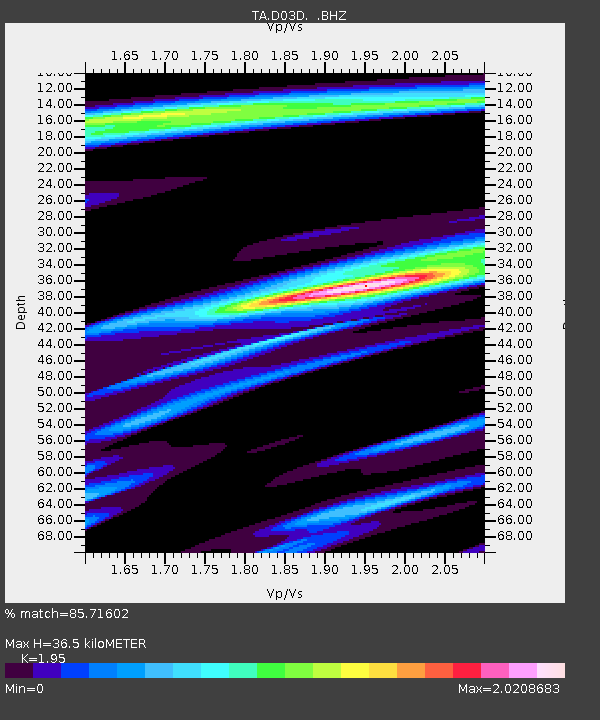
D03D Eldon, WA, USA - Earthquake Result Viewer

Earthquake location: Near Coast Of Chiapas, Mexico
Earthquake latitude/longitude: 14.2/-92.3
Earthquake time(UTC): 2012/07/29 (211) 12:22:11 GMT
Earthquake Depth: 18 km
Earthquake Magnitude: 5.6 MB, 5.5 MS, 5.9 MW, 5.8 MW
Earthquake Catalog/Contributor: WHDF/NEIC
Network: TA USArray Transportable Network (new EarthScope stations)
Station: D03D Eldon, WA, USA
Lat/Lon: 47.53 N/123.09 W
Elevation: 262 m
Distance: 42.0 deg
Az: 328.74 deg
Baz: 132.034 deg
Ray Param: 0.07344237
Estimated Moho Depth: 36.5 km
Estimated Crust Vp/Vs: 1.95
Assumed Crust Vp: 6.566 km/s
Estimated Crust Vs: 3.367 km/s
Estimated Crust Poisson's Ratio: 0.32
Radial Match: 85.71602 %
Radial Bump: 400
Transverse Match: 72.55881 %
Transverse Bump: 400
SOD ConfigId: 469095
Insert Time: 2013-02-22 02:39:30.514 +0000
GWidth: 2.5
Max Bumps: 400
Tol: 0.001

Signal To Noise

ChannelStoNSTALTA
TA:D03D: :BHZ:20120729T12:29:30.67499Z13.2887886.7336623E-75.067176E-8
TA:D03D: :BHN:20120729T12:29:30.67499Z8.0754613.0612694E-73.790829E-8
TA:D03D: :BHE:20120729T12:29:30.67499Z12.6008643.7155934E-72.9486813E-8
Arrivals
Ps5.6 SECOND
PpPs15 SECOND
PsPs/PpSs21 SECOND