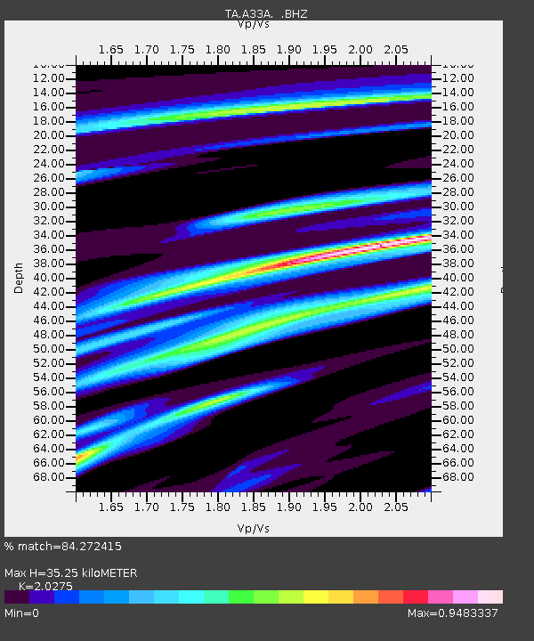
A33A Warroad, MN, USA - Earthquake Result Viewer
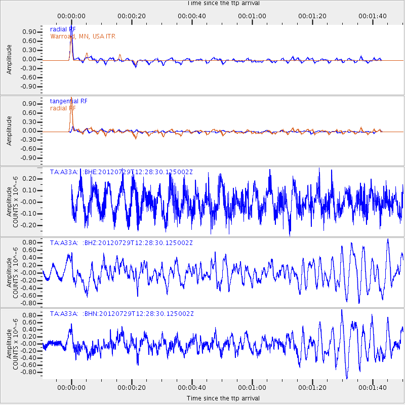
Earthquake location: Near Coast Of Chiapas, Mexico
Earthquake latitude/longitude: 14.2/-92.3
Earthquake time(UTC): 2012/07/29 (211) 12:22:11 GMT
Earthquake Depth: 18 km
Earthquake Magnitude: 5.6 MB, 5.5 MS, 5.9 MW, 5.8 MW
Earthquake Catalog/Contributor: WHDF/NEIC
Network: TA USArray Transportable Network (new EarthScope stations)
Station: A33A Warroad, MN, USA
Lat/Lon: 48.94 N/95.39 W
Elevation: 329 m
Distance: 34.7 deg
Az: 356.417 deg
Baz: 174.725 deg
Ray Param: 0.0775664
Estimated Moho Depth: 35.25 km
Estimated Crust Vp/Vs: 2.03
Assumed Crust Vp: 6.419 km/s
Estimated Crust Vs: 3.166 km/s
Estimated Crust Poisson's Ratio: 0.34
Radial Match: 84.272415 %
Radial Bump: 329
Transverse Match: 55.184807 %
Transverse Bump: 400
SOD ConfigId: 469095
Insert Time: 2013-02-22 02:40:50.183 +0000
GWidth: 2.5
Max Bumps: 400
Tol: 0.001

Signal To Noise

ChannelStoNSTALTA
TA:A33A: :BHZ:20120729T12:28:30.125002Z2.46139722.8991525E-71.1778483E-7
TA:A33A: :BHN:20120729T12:28:30.125002Z2.4569132.2405888E-79.119528E-8
TA:A33A: :BHE:20120729T12:28:30.125002Z1.07646751.2508332E-71.1619795E-7
Arrivals
Ps6.0 SECOND
PpPs16 SECOND
PsPs/PpSs22 SECOND