You are here: Home > Network List > G - GEOSCOPE Stations List
> Station TAM Tamanrasset, Algeria > Earthquake Result Viewer
TAM Tamanrasset, Algeria - Earthquake Result Viewer
| Earthquake location: |
South Sandwich Islands Region |
| Earthquake latitude/longitude: |
-56.1/-27.9 |
| Earthquake time(UTC): |
1993/03/20 (079) 09:20:34 GMT |
| Earthquake Depth: |
130 km |
| Earthquake Magnitude: |
5.9 MB |
| Earthquake Catalog/Contributor: |
WHDF/NEIC |
|
| Network: |
G GEOSCOPE |
| Station: |
TAM Tamanrasset, Algeria |
| Lat/Lon: |
22.79 N/5.53 E |
| Elevation: |
1377 m |
|
| Distance: |
83.5 deg |
| Az: |
30.793 deg |
| Baz: |
198.118 deg |
| Ray Param: |
0.045826998 |
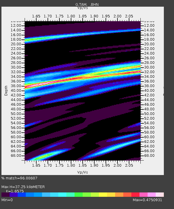
| Estimated Moho Depth: |
37.25 km |
| Estimated Crust Vp/Vs: |
1.66 |
| Assumed Crust Vp: |
6.61 km/s |
| Estimated Crust Vs: |
3.988 km/s |
| Estimated Crust Poisson's Ratio: |
0.21 |
|
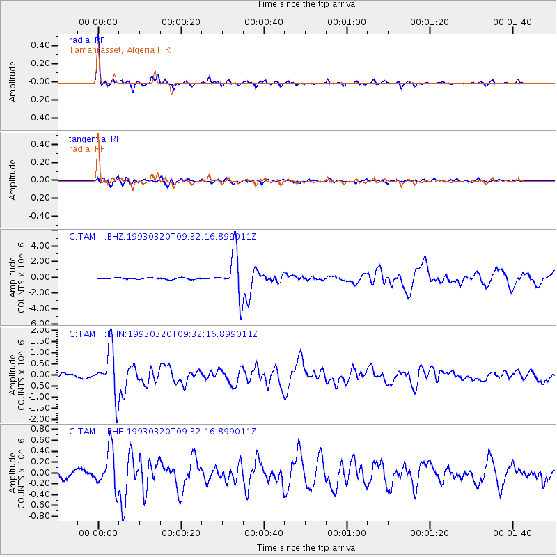
| Radial Match: |
96.88687 % |
| Radial Bump: |
259 |
| Transverse Match: |
82.92969 % |
| Transverse Bump: |
400 |
| SOD ConfigId: |
17000 |
| Insert Time: |
2010-02-27 00:27:40.310 +0000 |
| GWidth: |
2.5 |
| Max Bumps: |
400 |
| Tol: |
0.001 |
|
Signal To Noise
| Channel | StoN | STA | LTA |
| G:TAM: :BHN:19930320T09:32:16.899011Z | 14.508605 | 1.0942206E-6 | 7.541873E-8 |
| G:TAM: :BHE:19930320T09:32:16.899011Z | 6.6577106 | 3.7593938E-7 | 5.6466764E-8 |
| G:TAM: :BHZ:19930320T09:32:16.899011Z | 32.23111 | 3.0399558E-6 | 9.4317436E-8 |
| Arrivals |
| Ps | 3.8 SECOND |
| PpPs | 15 SECOND |
| PsPs/PpSs | 18 SECOND |


