You are here: Home > Network List > TA - USArray Transportable Network (new EarthScope stations) Stations List
> Station E41A Kenton, MI, USA > Earthquake Result Viewer
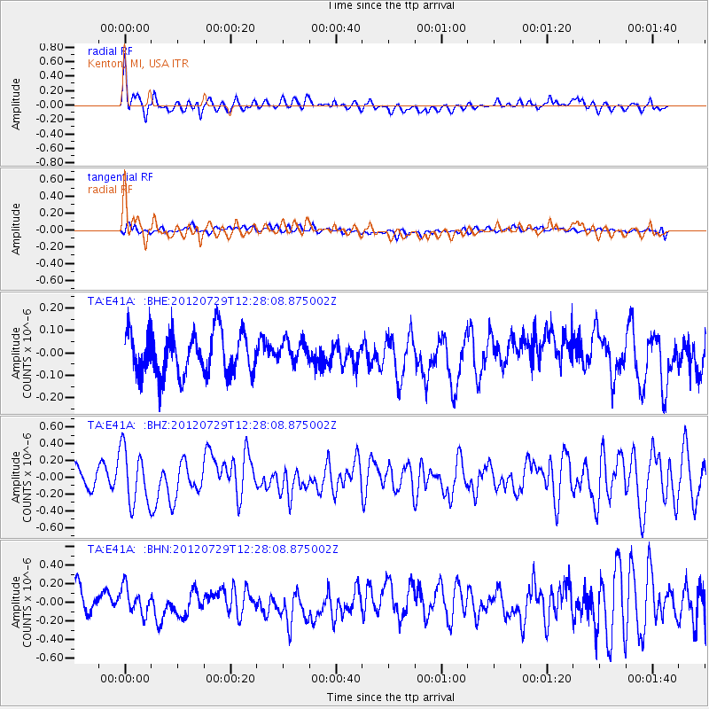
E41A Kenton, MI, USA - Earthquake Result Viewer
*The percent match for this event was below the threshold and hence no stack was calculated.
| Earthquake location: |
Near Coast Of Chiapas, Mexico |
| Earthquake latitude/longitude: |
14.2/-92.3 |
| Earthquake time(UTC): |
2012/07/29 (211) 12:22:11 GMT |
| Earthquake Depth: |
18 km |
| Earthquake Magnitude: |
5.6 MB, 5.5 MS, 5.9 MW, 5.8 MW |
| Earthquake Catalog/Contributor: |
WHDF/NEIC |
|
| Network: |
TA USArray Transportable Network (new EarthScope stations) |
| Station: |
E41A Kenton, MI, USA |
| Lat/Lon: |
46.46 N/88.96 W |
| Elevation: |
377 m |
|
| Distance: |
32.3 deg |
| Az: |
4.311 deg |
| Baz: |
186.054 deg |
| Ray Param: |
$rayparam |
*The percent match for this event was below the threshold and hence was not used in the summary stack. |
|
| Radial Match: |
64.987755 % |
| Radial Bump: |
400 |
| Transverse Match: |
39.083954 % |
| Transverse Bump: |
400 |
| SOD ConfigId: |
469095 |
| Insert Time: |
2013-02-22 02:42:53.026 +0000 |
| GWidth: |
2.5 |
| Max Bumps: |
400 |
| Tol: |
0.001 |
|
Signal To Noise
| Channel | StoN | STA | LTA |
| TA:E41A: :BHZ:20120729T12:28:08.875002Z | 2.5000334 | 3.317379E-7 | 1.3269339E-7 |
| TA:E41A: :BHN:20120729T12:28:08.875002Z | 0.86896664 | 1.4319119E-7 | 1.6478329E-7 |
| TA:E41A: :BHE:20120729T12:28:08.875002Z | 0.5258192 | 5.0167593E-8 | 9.5408446E-8 |
| Arrivals |
| Ps | |
| PpPs | |
| PsPs/PpSs | |


