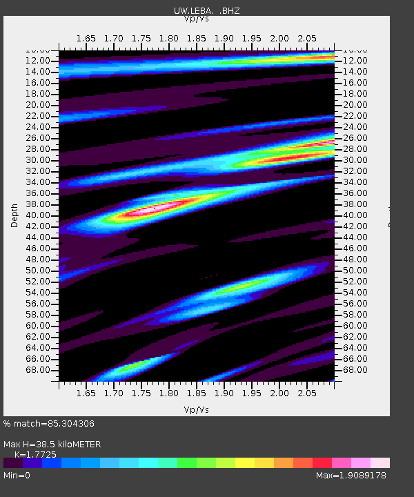
LEBA Lebam, WA, USA - Earthquake Result Viewer
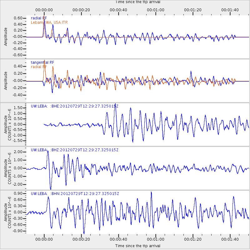
Earthquake location: Near Coast Of Chiapas, Mexico
Earthquake latitude/longitude: 14.2/-92.3
Earthquake time(UTC): 2012/07/29 (211) 12:22:11 GMT
Earthquake Depth: 18 km
Earthquake Magnitude: 5.6 MB, 5.5 MS, 5.9 MW, 5.8 MW
Earthquake Catalog/Contributor: WHDF/NEIC
Network: UW Pacific Northwest Regional Seismic Network
Station: LEBA Lebam, WA, USA
Lat/Lon: 46.55 N/123.56 W
Elevation: 73 m
Distance: 41.5 deg
Az: 327.303 deg
Baz: 130.616 deg
Ray Param: 0.0737041
Estimated Moho Depth: 38.5 km
Estimated Crust Vp/Vs: 1.77
Assumed Crust Vp: 6.566 km/s
Estimated Crust Vs: 3.704 km/s
Estimated Crust Poisson's Ratio: 0.27
Radial Match: 85.304306 %
Radial Bump: 400
Transverse Match: 87.010864 %
Transverse Bump: 372
SOD ConfigId: 469095
Insert Time: 2013-02-22 02:45:50.450 +0000
GWidth: 2.5
Max Bumps: 400
Tol: 0.001

Signal To Noise

ChannelStoNSTALTA
UW:LEBA: :BHZ:20120729T12:29:27.325015Z17.5392361.259272E-67.179743E-8
UW:LEBA: :BHN:20120729T12:29:27.325015Z5.24381884.2160448E-78.040028E-8
UW:LEBA: :BHE:20120729T12:29:27.325015Z7.0317435.408495E-77.691542E-8
Arrivals
Ps4.9 SECOND
PpPs15 SECOND
PsPs/PpSs20 SECOND