You are here: Home > Network List > G - GEOSCOPE Stations List
> Station TAM Tamanrasset, Algeria > Earthquake Result Viewer
TAM Tamanrasset, Algeria - Earthquake Result Viewer
| Earthquake location: |
Peru-Bolivia Border Region |
| Earthquake latitude/longitude: |
-17.5/-69.7 |
| Earthquake time(UTC): |
1994/12/12 (346) 07:41:55 GMT |
| Earthquake Depth: |
151 km |
| Earthquake Magnitude: |
5.8 MB, 6.1 UNKNOWN, 6.3 MW |
| Earthquake Catalog/Contributor: |
WHDF/NEIC |
|
| Network: |
G GEOSCOPE |
| Station: |
TAM Tamanrasset, Algeria |
| Lat/Lon: |
22.79 N/5.53 E |
| Elevation: |
1377 m |
|
| Distance: |
83.7 deg |
| Az: |
63.844 deg |
| Baz: |
248.15 deg |
| Ray Param: |
0.045672156 |
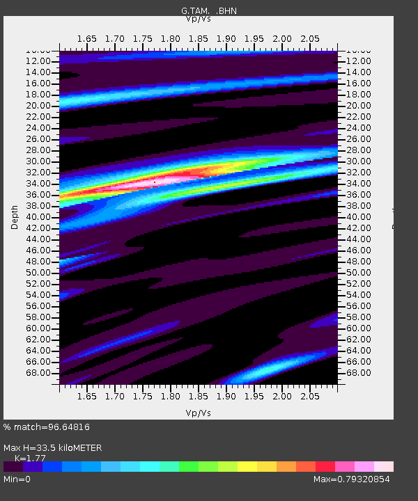
| Estimated Moho Depth: |
33.5 km |
| Estimated Crust Vp/Vs: |
1.77 |
| Assumed Crust Vp: |
6.61 km/s |
| Estimated Crust Vs: |
3.734 km/s |
| Estimated Crust Poisson's Ratio: |
0.27 |
|
| Radial Match: |
96.64816 % |
| Radial Bump: |
359 |
| Transverse Match: |
90.66268 % |
| Transverse Bump: |
400 |
| SOD ConfigId: |
16938 |
| Insert Time: |
2010-02-27 00:28:06.226 +0000 |
| GWidth: |
2.5 |
| Max Bumps: |
400 |
| Tol: |
0.001 |
|
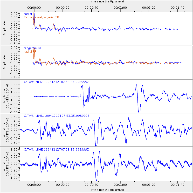
Signal To Noise
| Channel | StoN | STA | LTA |
| G:TAM: :BHN:19941212T07:53:35.998999Z | 4.7240047 | 2.182125E-7 | 4.6192266E-8 |
| G:TAM: :BHE:19941212T07:53:35.998999Z | 5.5790462 | 3.8524132E-7 | 6.905147E-8 |
| G:TAM: :BHZ:19941212T07:53:35.998999Z | 21.799625 | 1.341723E-6 | 6.154798E-8 |
| Arrivals |
| Ps | 4.0 SECOND |
| PpPs | 14 SECOND |
| PsPs/PpSs | 18 SECOND |


