You are here: Home > Network List > AZ - ANZA Regional Network Stations List
> Station FRD AZ.FRD > Earthquake Result Viewer
FRD AZ.FRD - Earthquake Result Viewer

| Earthquake location: |
Peru-Brazil Border Region |
| Earthquake latitude/longitude: |
-8.4/-74.3 |
| Earthquake time(UTC): |
2012/08/02 (215) 09:38:30 GMT |
| Earthquake Depth: |
145 km |
| Earthquake Magnitude: |
5.9 MB, 6.1 MW, 6.1 MW |
| Earthquake Catalog/Contributor: |
WHDF/NEIC |
|
| Network: |
AZ ANZA Regional Network |
| Station: |
FRD AZ.FRD |
| Lat/Lon: |
33.49 N/116.60 W |
| Elevation: |
1164 m |
|
| Distance: |
57.9 deg |
| Az: |
318.367 deg |
| Baz: |
128.133 deg |
| Ray Param: |
0.06273607 |
| Estimated Moho Depth: |
28.25 km |
| Estimated Crust Vp/Vs: |
1.62 |
| Assumed Crust Vp: |
6.264 km/s |
| Estimated Crust Vs: |
3.872 km/s |
| Estimated Crust Poisson's Ratio: |
0.19 |
|
| Radial Match: |
94.43075 % |
| Radial Bump: |
400 |
| Transverse Match: |
78.73544 % |
| Transverse Bump: |
400 |
| SOD ConfigId: |
469095 |
| Insert Time: |
2013-02-22 02:55:18.140 +0000 |
| GWidth: |
2.5 |
| Max Bumps: |
400 |
| Tol: |
0.001 |
|
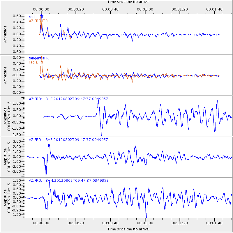
Signal To Noise
| Channel | StoN | STA | LTA |
| AZ:FRD: :BHZ:20120802T09:47:37.094995Z | 17.789692 | 1.5053928E-6 | 8.4621625E-8 |
| AZ:FRD: :BHN:20120802T09:47:37.094995Z | 9.143545 | 4.481183E-7 | 4.900925E-8 |
| AZ:FRD: :BHE:20120802T09:47:37.094995Z | 7.525443 | 6.4475523E-7 | 8.567672E-8 |
| Arrivals |
| Ps | 2.9 SECOND |
| PpPs | 11 SECOND |
| PsPs/PpSs | 14 SECOND |


