You are here: Home > Network List > AZ - ANZA Regional Network Stations List
> Station MONP2 Monument Peak TA Vault, Mt. Laguna, CA, USA > Earthquake Result Viewer
MONP2 Monument Peak TA Vault, Mt. Laguna, CA, USA - Earthquake Result Viewer

| Earthquake location: |
Peru-Brazil Border Region |
| Earthquake latitude/longitude: |
-8.4/-74.3 |
| Earthquake time(UTC): |
2012/08/02 (215) 09:38:30 GMT |
| Earthquake Depth: |
145 km |
| Earthquake Magnitude: |
5.9 MB, 6.1 MW, 6.1 MW |
| Earthquake Catalog/Contributor: |
WHDF/NEIC |
|
| Network: |
AZ ANZA Regional Network |
| Station: |
MONP2 Monument Peak TA Vault, Mt. Laguna, CA, USA |
| Lat/Lon: |
32.89 N/116.42 W |
| Elevation: |
1000 m |
|
| Distance: |
57.4 deg |
| Az: |
317.917 deg |
| Baz: |
127.99 deg |
| Ray Param: |
0.063052036 |
| Estimated Moho Depth: |
28.75 km |
| Estimated Crust Vp/Vs: |
1.74 |
| Assumed Crust Vp: |
6.264 km/s |
| Estimated Crust Vs: |
3.61 km/s |
| Estimated Crust Poisson's Ratio: |
0.25 |
|
| Radial Match: |
88.80258 % |
| Radial Bump: |
395 |
| Transverse Match: |
84.94795 % |
| Transverse Bump: |
357 |
| SOD ConfigId: |
469095 |
| Insert Time: |
2013-02-22 02:56:14.419 +0000 |
| GWidth: |
2.5 |
| Max Bumps: |
400 |
| Tol: |
0.001 |
|
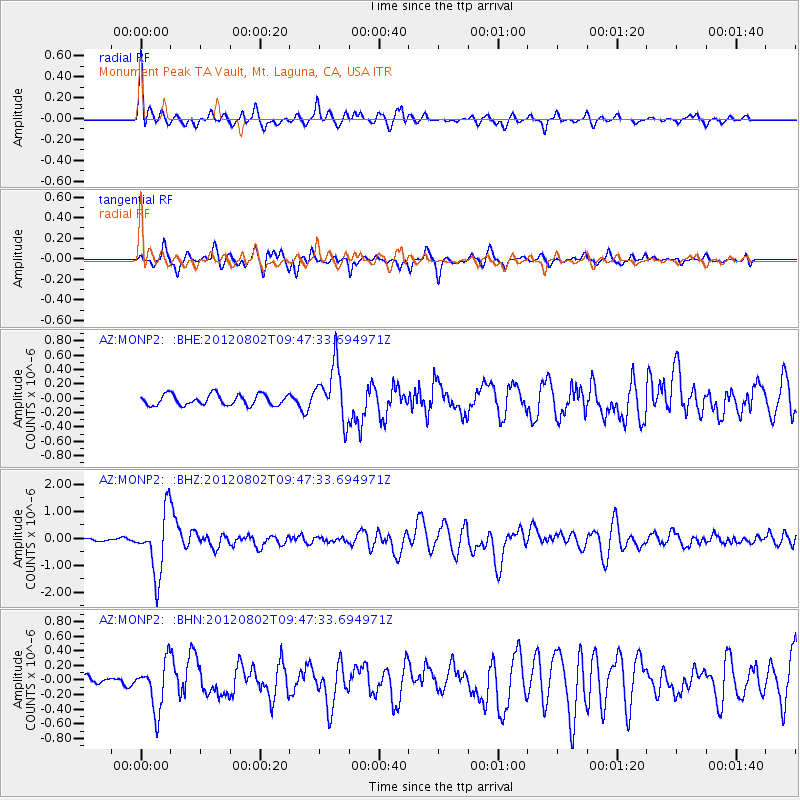
Signal To Noise
| Channel | StoN | STA | LTA |
| AZ:MONP2: :BHZ:20120802T09:47:33.694971Z | 14.8831 | 1.1448816E-6 | 7.692494E-8 |
| AZ:MONP2: :BHN:20120802T09:47:33.694971Z | 5.057885 | 3.3108452E-7 | 6.545908E-8 |
| AZ:MONP2: :BHE:20120802T09:47:33.694971Z | 5.0964236 | 3.8246728E-7 | 7.504621E-8 |
| Arrivals |
| Ps | 3.5 SECOND |
| PpPs | 12 SECOND |
| PsPs/PpSs | 16 SECOND |


