You are here: Home > Network List > CI - Caltech Regional Seismic Network Stations List
> Station SVD Seven Oaks Dam, California, USA > Earthquake Result Viewer
SVD Seven Oaks Dam, California, USA - Earthquake Result Viewer
| Earthquake location: |
Peru-Brazil Border Region |
| Earthquake latitude/longitude: |
-8.4/-74.3 |
| Earthquake time(UTC): |
2012/08/02 (215) 09:38:30 GMT |
| Earthquake Depth: |
145 km |
| Earthquake Magnitude: |
5.9 MB, 6.1 MW, 6.1 MW |
| Earthquake Catalog/Contributor: |
WHDF/NEIC |
|
| Network: |
CI Caltech Regional Seismic Network |
| Station: |
SVD Seven Oaks Dam, California, USA |
| Lat/Lon: |
34.11 N/117.10 W |
| Elevation: |
574 m |
|
| Distance: |
58.6 deg |
| Az: |
318.633 deg |
| Baz: |
127.997 deg |
| Ray Param: |
0.062280394 |
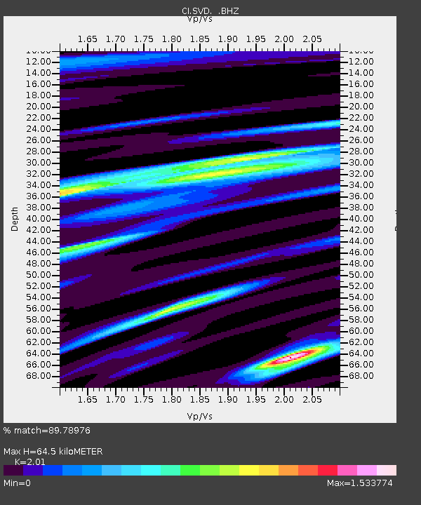
| Estimated Moho Depth: |
64.5 km |
| Estimated Crust Vp/Vs: |
2.01 |
| Assumed Crust Vp: |
6.276 km/s |
| Estimated Crust Vs: |
3.122 km/s |
| Estimated Crust Poisson's Ratio: |
0.34 |
|
| Radial Match: |
89.78976 % |
| Radial Bump: |
359 |
| Transverse Match: |
83.14052 % |
| Transverse Bump: |
400 |
| SOD ConfigId: |
469095 |
| Insert Time: |
2013-02-22 02:58:08.950 +0000 |
| GWidth: |
2.5 |
| Max Bumps: |
400 |
| Tol: |
0.001 |
|
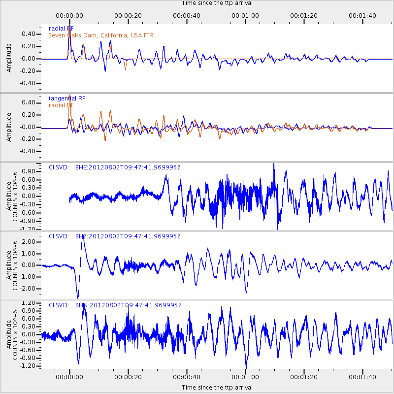
Signal To Noise
| Channel | StoN | STA | LTA |
| CI:SVD: :BHZ:20120802T09:47:41.969995Z | 18.284433 | 1.4020806E-6 | 7.668165E-8 |
| CI:SVD: :BHN:20120802T09:47:41.969995Z | 6.0514755 | 4.9778345E-7 | 8.22582E-8 |
| CI:SVD: :BHE:20120802T09:47:41.969995Z | 4.0351624 | 3.5513847E-7 | 8.801094E-8 |
| Arrivals |
| Ps | 11 SECOND |
| PpPs | 30 SECOND |
| PsPs/PpSs | 41 SECOND |


