You are here: Home > Network List > G - GEOSCOPE Stations List
> Station TAM Tamanrasset, Algeria > Earthquake Result Viewer
TAM Tamanrasset, Algeria - Earthquake Result Viewer
| Earthquake location: |
Chiapas, Mexico |
| Earthquake latitude/longitude: |
16.9/-93.5 |
| Earthquake time(UTC): |
1995/10/21 (294) 02:38:57 GMT |
| Earthquake Depth: |
161 km |
| Earthquake Magnitude: |
6.2 MB, 7.3 UNKNOWN, 7.3 MW |
| Earthquake Catalog/Contributor: |
WHDF/NEIC |
|
| Network: |
G GEOSCOPE |
| Station: |
TAM Tamanrasset, Algeria |
| Lat/Lon: |
22.79 N/5.53 E |
| Elevation: |
1377 m |
|
| Distance: |
91.5 deg |
| Az: |
65.765 deg |
| Baz: |
288.913 deg |
| Ray Param: |
0.041523833 |
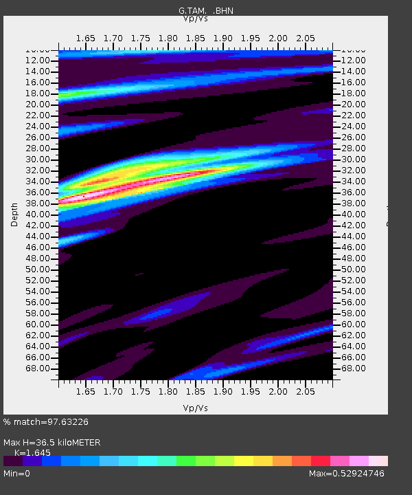
| Estimated Moho Depth: |
36.5 km |
| Estimated Crust Vp/Vs: |
1.64 |
| Assumed Crust Vp: |
6.61 km/s |
| Estimated Crust Vs: |
4.018 km/s |
| Estimated Crust Poisson's Ratio: |
0.21 |
|
| Radial Match: |
97.63226 % |
| Radial Bump: |
293 |
| Transverse Match: |
79.55673 % |
| Transverse Bump: |
400 |
| SOD ConfigId: |
6273 |
| Insert Time: |
2010-02-27 00:28:26.771 +0000 |
| GWidth: |
2.5 |
| Max Bumps: |
400 |
| Tol: |
0.001 |
|
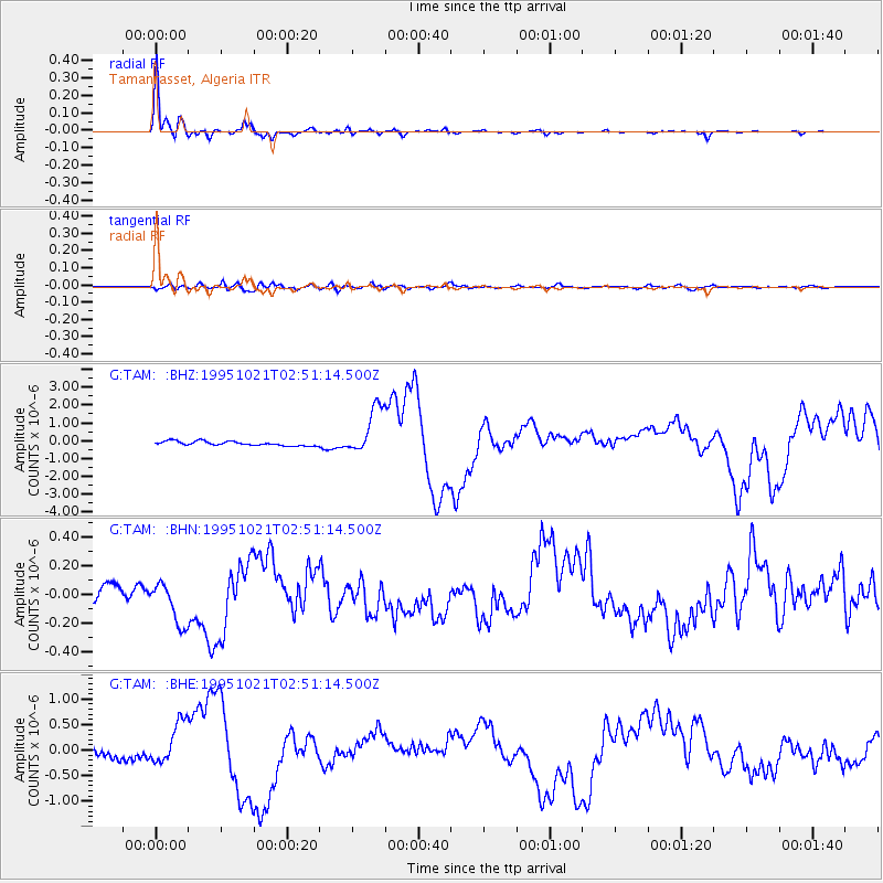
Signal To Noise
| Channel | StoN | STA | LTA |
| G:TAM: :BHN:19951021T02:51:14.500Z | 2.7587614 | 1.5178179E-7 | 5.501809E-8 |
| G:TAM: :BHE:19951021T02:51:14.500Z | 5.386849 | 4.262902E-7 | 7.913536E-8 |
| G:TAM: :BHZ:19951021T02:51:14.500Z | 11.13295 | 1.3609109E-6 | 1.2224172E-7 |
| Arrivals |
| Ps | 3.6 SECOND |
| PpPs | 14 SECOND |
| PsPs/PpSs | 18 SECOND |


