You are here: Home > Network List > CI - Caltech Regional Seismic Network Stations List
> Station MPP McPhearson Peak > Earthquake Result Viewer
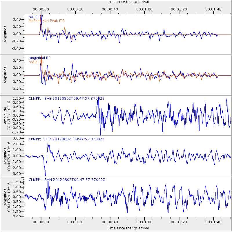
MPP McPhearson Peak - Earthquake Result Viewer
*The percent match for this event was below the threshold and hence no stack was calculated.
| Earthquake location: |
Peru-Brazil Border Region |
| Earthquake latitude/longitude: |
-8.4/-74.3 |
| Earthquake time(UTC): |
2012/08/02 (215) 09:38:30 GMT |
| Earthquake Depth: |
145 km |
| Earthquake Magnitude: |
5.9 MB, 6.1 MW, 6.1 MW |
| Earthquake Catalog/Contributor: |
WHDF/NEIC |
|
| Network: |
CI Caltech Regional Seismic Network |
| Station: |
MPP McPhearson Peak |
| Lat/Lon: |
34.89 N/119.81 W |
| Elevation: |
1739 m |
|
| Distance: |
60.9 deg |
| Az: |
317.79 deg |
| Baz: |
126.042 deg |
| Ray Param: |
$rayparam |
*The percent match for this event was below the threshold and hence was not used in the summary stack. |
|
| Radial Match: |
79.59807 % |
| Radial Bump: |
400 |
| Transverse Match: |
74.18522 % |
| Transverse Bump: |
400 |
| SOD ConfigId: |
469095 |
| Insert Time: |
2013-02-22 03:00:45.927 +0000 |
| GWidth: |
2.5 |
| Max Bumps: |
400 |
| Tol: |
0.001 |
|
Signal To Noise
| Channel | StoN | STA | LTA |
| CI:MPP: :BHZ:20120802T09:47:57.37002Z | 10.771118 | 1.358515E-6 | 1.2612571E-7 |
| CI:MPP: :BHN:20120802T09:47:57.37002Z | 2.899283 | 6.664583E-7 | 2.2987004E-7 |
| CI:MPP: :BHE:20120802T09:47:57.37002Z | 2.046434 | 5.3386685E-7 | 2.6087665E-7 |
| Arrivals |
| Ps | |
| PpPs | |
| PsPs/PpSs | |


