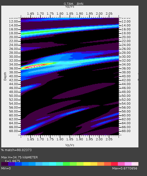
TAM Tamanrasset, Algeria - Earthquake Result Viewer
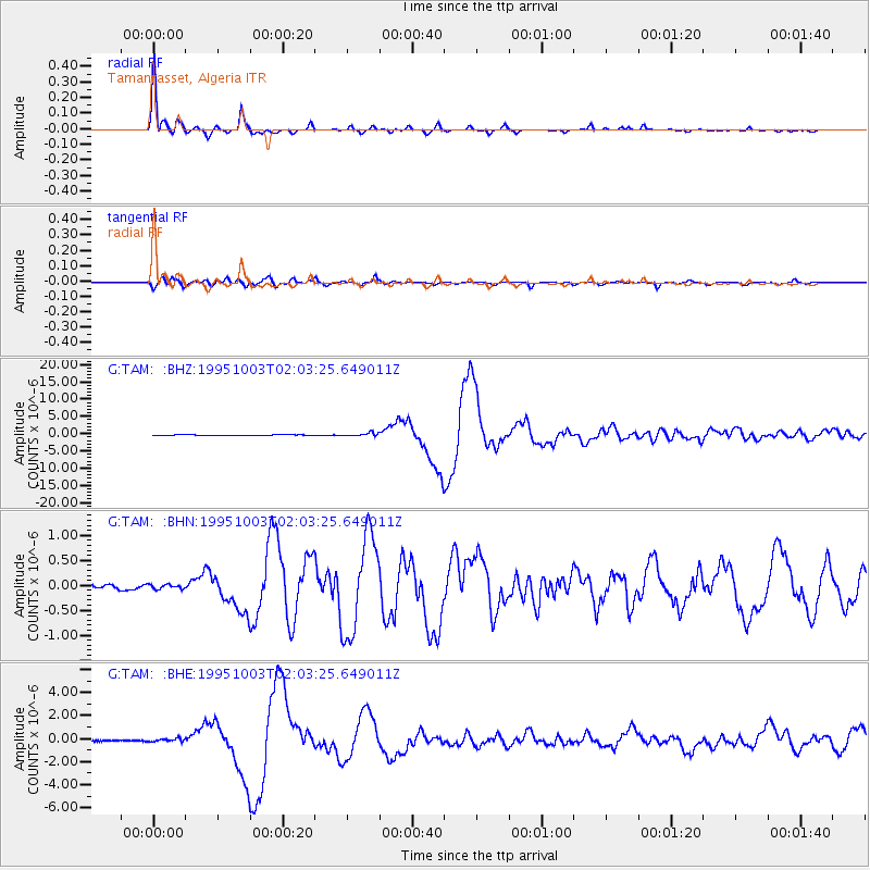
Earthquake location: Peru-Ecuador Border Region
Earthquake latitude/longitude: -2.8/-77.9
Earthquake time(UTC): 1995/10/03 (276) 01:51:24 GMT
Earthquake Depth: 27 km
Earthquake Magnitude: 6.5 MB, 7.0 MS, 6.9 UNKNOWN, 7.0 MW
Earthquake Catalog/Contributor: WHDF/NEIC
Network: G GEOSCOPE
Station: TAM Tamanrasset, Algeria
Lat/Lon: 22.79 N/5.53 E
Elevation: 1377 m
Distance: 85.0 deg
Az: 66.965 deg
Baz: 264.903 deg
Ray Param: 0.045051668
Estimated Moho Depth: 34.75 km
Estimated Crust Vp/Vs: 1.67
Assumed Crust Vp: 6.61 km/s
Estimated Crust Vs: 3.964 km/s
Estimated Crust Poisson's Ratio: 0.22
Radial Match: 98.82373 %
Radial Bump: 261
Transverse Match: 94.770065 %
Transverse Bump: 400
SOD ConfigId: 6273
Insert Time: 2010-02-27 00:28:31.286 +0000
GWidth: 2.5
Max Bumps: 400
Tol: 0.001

Signal To Noise

ChannelStoNSTALTA
G:TAM: :BHN:19951003T02:03:25.649011Z0.64076954.638428E-87.23884E-8
G:TAM: :BHE:19951003T02:03:25.649011Z2.16131621.4593749E-76.752251E-8
G:TAM: :BHZ:19951003T02:03:25.649011Z4.94729144.5991902E-79.296381E-8
Arrivals
Ps3.6 SECOND
PpPs14 SECOND
PsPs/PpSs17 SECOND