You are here: Home > Network List > CI - Caltech Regional Seismic Network Stations List
> Station BFS Mt Baldy Forest Station > Earthquake Result Viewer
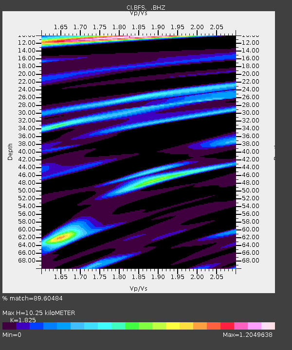
BFS Mt Baldy Forest Station - Earthquake Result Viewer
| Earthquake location: |
Peru-Brazil Border Region |
| Earthquake latitude/longitude: |
-8.4/-74.3 |
| Earthquake time(UTC): |
2012/08/02 (215) 09:38:30 GMT |
| Earthquake Depth: |
145 km |
| Earthquake Magnitude: |
5.9 MB, 6.1 MW, 6.1 MW |
| Earthquake Catalog/Contributor: |
WHDF/NEIC |
|
| Network: |
CI Caltech Regional Seismic Network |
| Station: |
BFS Mt Baldy Forest Station |
| Lat/Lon: |
34.24 N/117.66 W |
| Elevation: |
1312 m |
|
| Distance: |
59.1 deg |
| Az: |
318.422 deg |
| Baz: |
127.575 deg |
| Ray Param: |
0.061987996 |
| Estimated Moho Depth: |
10.25 km |
| Estimated Crust Vp/Vs: |
1.83 |
| Assumed Crust Vp: |
6.276 km/s |
| Estimated Crust Vs: |
3.439 km/s |
| Estimated Crust Poisson's Ratio: |
0.29 |
|
| Radial Match: |
89.60484 % |
| Radial Bump: |
357 |
| Transverse Match: |
81.42164 % |
| Transverse Bump: |
400 |
| SOD ConfigId: |
469095 |
| Insert Time: |
2013-02-22 03:01:10.403 +0000 |
| GWidth: |
2.5 |
| Max Bumps: |
400 |
| Tol: |
0.001 |
|

Signal To Noise
| Channel | StoN | STA | LTA |
| CI:BFS: :BHZ:20120802T09:47:45.045007Z | 21.939243 | 1.1942878E-6 | 5.4436146E-8 |
| CI:BFS: :BHN:20120802T09:47:45.045007Z | 8.309806 | 3.624281E-7 | 4.3614506E-8 |
| CI:BFS: :BHE:20120802T09:47:45.045007Z | 6.6729217 | 4.0157022E-7 | 6.017907E-8 |
| Arrivals |
| Ps | 1.4 SECOND |
| PpPs | 4.4 SECOND |
| PsPs/PpSs | 5.8 SECOND |


