You are here: Home > Network List > CI - Caltech Regional Seismic Network Stations List
> Station GMR Granite Mountains Research Center > Earthquake Result Viewer
GMR Granite Mountains Research Center - Earthquake Result Viewer
| Earthquake location: |
Peru-Brazil Border Region |
| Earthquake latitude/longitude: |
-8.4/-74.3 |
| Earthquake time(UTC): |
2012/08/02 (215) 09:38:30 GMT |
| Earthquake Depth: |
145 km |
| Earthquake Magnitude: |
5.9 MB, 6.1 MW, 6.1 MW |
| Earthquake Catalog/Contributor: |
WHDF/NEIC |
|
| Network: |
CI Caltech Regional Seismic Network |
| Station: |
GMR Granite Mountains Research Center |
| Lat/Lon: |
34.78 N/115.66 W |
| Elevation: |
1326 m |
|
| Distance: |
58.1 deg |
| Az: |
320.127 deg |
| Baz: |
129.591 deg |
| Ray Param: |
0.06260774 |
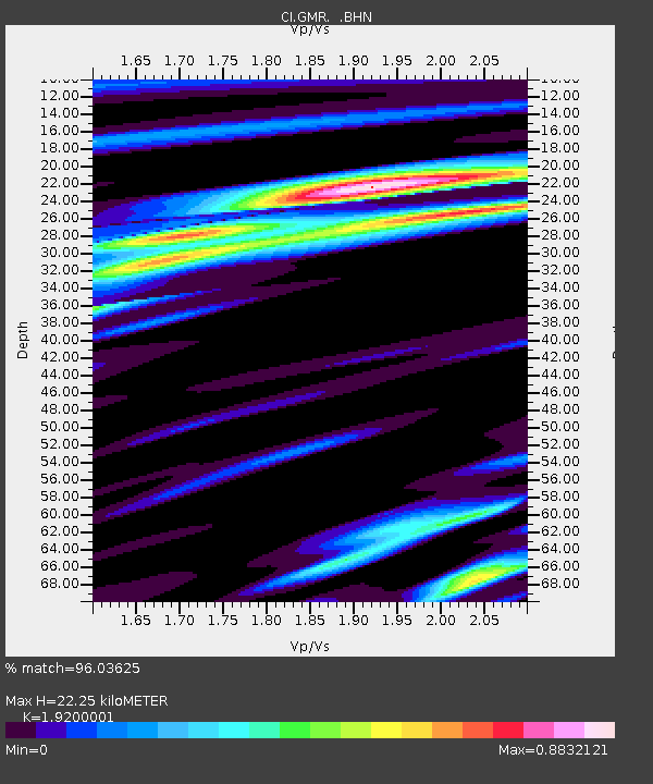
| Estimated Moho Depth: |
22.25 km |
| Estimated Crust Vp/Vs: |
1.92 |
| Assumed Crust Vp: |
6.276 km/s |
| Estimated Crust Vs: |
3.269 km/s |
| Estimated Crust Poisson's Ratio: |
0.31 |
|
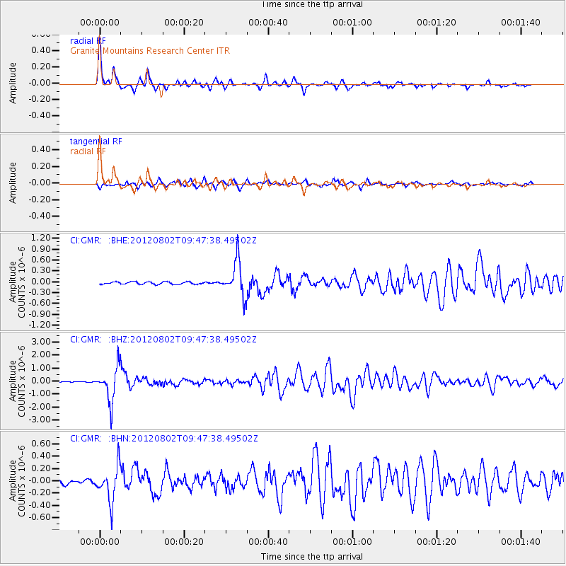
| Radial Match: |
96.03625 % |
| Radial Bump: |
322 |
| Transverse Match: |
80.182625 % |
| Transverse Bump: |
400 |
| SOD ConfigId: |
469095 |
| Insert Time: |
2013-02-22 03:01:56.075 +0000 |
| GWidth: |
2.5 |
| Max Bumps: |
400 |
| Tol: |
0.001 |
|
Signal To Noise
| Channel | StoN | STA | LTA |
| CI:GMR: :BHZ:20120802T09:47:38.49502Z | 25.478577 | 1.3338422E-6 | 5.235152E-8 |
| CI:GMR: :BHN:20120802T09:47:38.49502Z | 5.422059 | 2.9674422E-7 | 5.4729068E-8 |
| CI:GMR: :BHE:20120802T09:47:38.49502Z | 14.8307085 | 4.9378383E-7 | 3.3294693E-8 |
| Arrivals |
| Ps | 3.4 SECOND |
| PpPs | 9.9 SECOND |
| PsPs/PpSs | 13 SECOND |


