You are here: Home > Network List > CN - Canadian National Seismograph Network Stations List
> Station GAC GLEN ALMOND, QC > Earthquake Result Viewer
GAC GLEN ALMOND, QC - Earthquake Result Viewer
| Earthquake location: |
Peru-Brazil Border Region |
| Earthquake latitude/longitude: |
-8.4/-74.3 |
| Earthquake time(UTC): |
2012/08/02 (215) 09:38:30 GMT |
| Earthquake Depth: |
145 km |
| Earthquake Magnitude: |
5.9 MB, 6.1 MW, 6.1 MW |
| Earthquake Catalog/Contributor: |
WHDF/NEIC |
|
| Network: |
CN Canadian National Seismograph Network |
| Station: |
GAC GLEN ALMOND, QC |
| Lat/Lon: |
45.70 N/75.48 W |
| Elevation: |
62 m |
|
| Distance: |
53.9 deg |
| Az: |
358.942 deg |
| Baz: |
178.507 deg |
| Ray Param: |
0.065338984 |
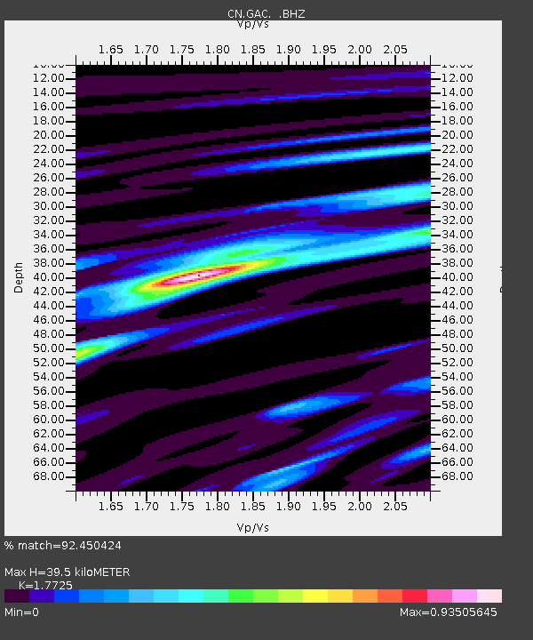
| Estimated Moho Depth: |
39.5 km |
| Estimated Crust Vp/Vs: |
1.77 |
| Assumed Crust Vp: |
6.419 km/s |
| Estimated Crust Vs: |
3.622 km/s |
| Estimated Crust Poisson's Ratio: |
0.27 |
|
| Radial Match: |
92.450424 % |
| Radial Bump: |
282 |
| Transverse Match: |
76.09432 % |
| Transverse Bump: |
400 |
| SOD ConfigId: |
469095 |
| Insert Time: |
2013-02-22 03:02:41.273 +0000 |
| GWidth: |
2.5 |
| Max Bumps: |
400 |
| Tol: |
0.001 |
|
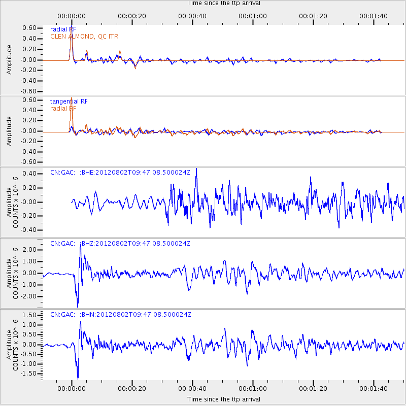
Signal To Noise
| Channel | StoN | STA | LTA |
| CN:GAC: :BHZ:20120802T09:47:08.500024Z | 10.094678 | 1.2337705E-6 | 1.222199E-7 |
| CN:GAC: :BHN:20120802T09:47:08.500024Z | 9.405935 | 6.7099205E-7 | 7.133709E-8 |
| CN:GAC: :BHE:20120802T09:47:08.500024Z | 2.275484 | 1.3483958E-7 | 5.9257534E-8 |
| Arrivals |
| Ps | 5.0 SECOND |
| PpPs | 16 SECOND |
| PsPs/PpSs | 21 SECOND |


