You are here: Home > Network List > CN - Canadian National Seismograph Network Stations List
> Station ULM LAC DU BONNET, MB > Earthquake Result Viewer
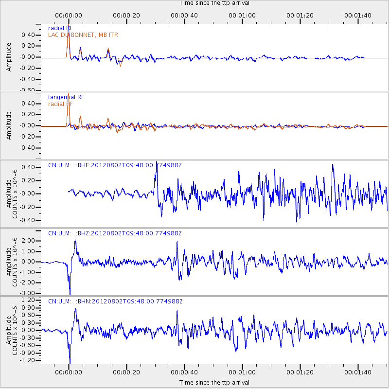
ULM LAC DU BONNET, MB - Earthquake Result Viewer

| Earthquake location: |
Peru-Brazil Border Region |
| Earthquake latitude/longitude: |
-8.4/-74.3 |
| Earthquake time(UTC): |
2012/08/02 (215) 09:38:30 GMT |
| Earthquake Depth: |
145 km |
| Earthquake Magnitude: |
5.9 MB, 6.1 MW, 6.1 MW |
| Earthquake Catalog/Contributor: |
WHDF/NEIC |
|
| Network: |
CN Canadian National Seismograph Network |
| Station: |
ULM LAC DU BONNET, MB |
| Lat/Lon: |
50.25 N/95.88 W |
| Elevation: |
251 m |
|
| Distance: |
61.4 deg |
| Az: |
344.371 deg |
| Baz: |
155.467 deg |
| Ray Param: |
0.060490817 |
| Estimated Moho Depth: |
33.5 km |
| Estimated Crust Vp/Vs: |
1.76 |
| Assumed Crust Vp: |
6.459 km/s |
| Estimated Crust Vs: |
3.675 km/s |
| Estimated Crust Poisson's Ratio: |
0.26 |
|
| Radial Match: |
93.88764 % |
| Radial Bump: |
391 |
| Transverse Match: |
71.47667 % |
| Transverse Bump: |
400 |
| SOD ConfigId: |
469095 |
| Insert Time: |
2013-02-22 03:02:53.184 +0000 |
| GWidth: |
2.5 |
| Max Bumps: |
400 |
| Tol: |
0.001 |
|
Signal To Noise
| Channel | StoN | STA | LTA |
| CN:ULM: :BHZ:20120802T09:48:00.774988Z | 20.989635 | 1.2311936E-6 | 5.8657214E-8 |
| CN:ULM: :BHN:20120802T09:48:00.774988Z | 12.007567 | 5.270376E-7 | 4.3892125E-8 |
| CN:ULM: :BHE:20120802T09:48:00.774988Z | 5.562826 | 1.9133846E-7 | 3.4395907E-8 |
| Arrivals |
| Ps | 4.1 SECOND |
| PpPs | 14 SECOND |
| PsPs/PpSs | 18 SECOND |


