You are here: Home > Network List > GT - Global Telemetered Seismograph Network (USAF/USGS) Stations List
> Station PLCA Paso Flores, Argentina > Earthquake Result Viewer
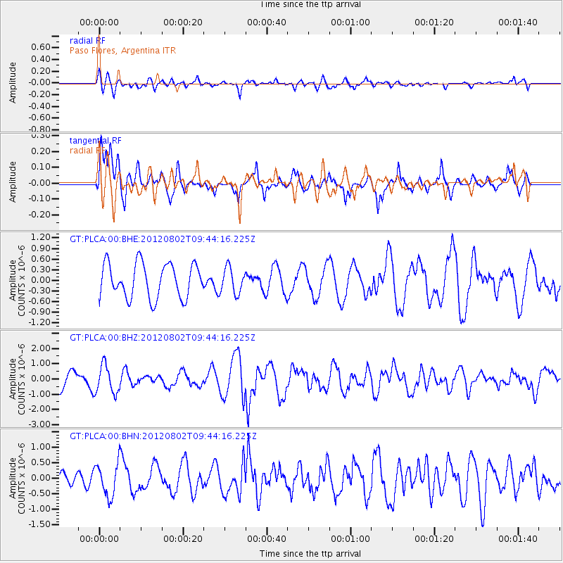
PLCA Paso Flores, Argentina - Earthquake Result Viewer
*The percent match for this event was below the threshold and hence no stack was calculated.
| Earthquake location: |
Peru-Brazil Border Region |
| Earthquake latitude/longitude: |
-8.4/-74.3 |
| Earthquake time(UTC): |
2012/08/02 (215) 09:38:30 GMT |
| Earthquake Depth: |
145 km |
| Earthquake Magnitude: |
5.9 MB, 6.1 MW, 6.1 MW |
| Earthquake Catalog/Contributor: |
WHDF/NEIC |
|
| Network: |
GT Global Telemetered Seismograph Network (USAF/USGS) |
| Station: |
PLCA Paso Flores, Argentina |
| Lat/Lon: |
40.73 S/70.55 W |
| Elevation: |
1050 m |
|
| Distance: |
32.4 deg |
| Az: |
174.73 deg |
| Baz: |
353.133 deg |
| Ray Param: |
$rayparam |
*The percent match for this event was below the threshold and hence was not used in the summary stack. |
|
| Radial Match: |
54.652462 % |
| Radial Bump: |
400 |
| Transverse Match: |
62.41068 % |
| Transverse Bump: |
400 |
| SOD ConfigId: |
469095 |
| Insert Time: |
2013-02-22 03:04:15.123 +0000 |
| GWidth: |
2.5 |
| Max Bumps: |
400 |
| Tol: |
0.001 |
|
Signal To Noise
| Channel | StoN | STA | LTA |
| GT:PLCA:00:BHZ:20120802T09:44:16.225Z | 2.0712328 | 9.2231267E-7 | 4.4529648E-7 |
| GT:PLCA:00:BHN:20120802T09:44:16.225Z | 1.8791342 | 5.3549223E-7 | 2.8496754E-7 |
| GT:PLCA:00:BHE:20120802T09:44:16.225Z | 0.73889285 | 3.5485303E-7 | 4.8024964E-7 |
| Arrivals |
| Ps | |
| PpPs | |
| PsPs/PpSs | |


