You are here: Home > Network List > G - GEOSCOPE Stations List
> Station TAM Tamanrasset, Algeria > Earthquake Result Viewer
TAM Tamanrasset, Algeria - Earthquake Result Viewer
| Earthquake location: |
Colombia |
| Earthquake latitude/longitude: |
5.1/-72.9 |
| Earthquake time(UTC): |
1995/01/19 (019) 15:05:03 GMT |
| Earthquake Depth: |
18 km |
| Earthquake Magnitude: |
6.4 MB, 6.6 MS, 6.5 UNKNOWN, 6.5 MW |
| Earthquake Catalog/Contributor: |
WHDF/NEIC |
|
| Network: |
G GEOSCOPE |
| Station: |
TAM Tamanrasset, Algeria |
| Lat/Lon: |
22.79 N/5.53 E |
| Elevation: |
1377 m |
|
| Distance: |
77.4 deg |
| Az: |
67.884 deg |
| Baz: |
270.249 deg |
| Ray Param: |
0.05032718 |
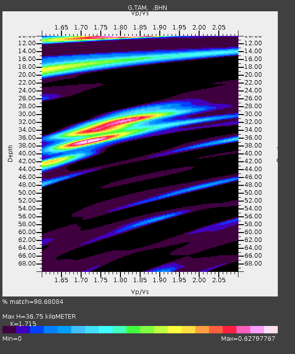
| Estimated Moho Depth: |
36.75 km |
| Estimated Crust Vp/Vs: |
1.72 |
| Assumed Crust Vp: |
6.61 km/s |
| Estimated Crust Vs: |
3.854 km/s |
| Estimated Crust Poisson's Ratio: |
0.24 |
|
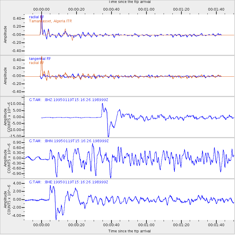
| Radial Match: |
98.68084 % |
| Radial Bump: |
367 |
| Transverse Match: |
89.68346 % |
| Transverse Bump: |
400 |
| SOD ConfigId: |
6273 |
| Insert Time: |
2010-02-27 00:28:46.003 +0000 |
| GWidth: |
2.5 |
| Max Bumps: |
400 |
| Tol: |
0.001 |
|
Signal To Noise
| Channel | StoN | STA | LTA |
| G:TAM: :BHN:19950119T15:16:26.198999Z | 0.9553277 | 7.167485E-8 | 7.502645E-8 |
| G:TAM: :BHE:19950119T15:16:26.198999Z | 8.0668125 | 5.7529223E-7 | 7.131593E-8 |
| G:TAM: :BHZ:19950119T15:16:26.198999Z | 15.447431 | 2.1186502E-6 | 1.3715227E-7 |
| Arrivals |
| Ps | 4.1 SECOND |
| PpPs | 15 SECOND |
| PsPs/PpSs | 19 SECOND |


