You are here: Home > Network List > LB - Leo Brady Network Stations List
> Station DAC Darwin, Inyo County, California, USA > Earthquake Result Viewer
DAC Darwin, Inyo County, California, USA - Earthquake Result Viewer
| Earthquake location: |
Peru-Brazil Border Region |
| Earthquake latitude/longitude: |
-8.4/-74.3 |
| Earthquake time(UTC): |
2012/08/02 (215) 09:38:30 GMT |
| Earthquake Depth: |
145 km |
| Earthquake Magnitude: |
5.9 MB, 6.1 MW, 6.1 MW |
| Earthquake Catalog/Contributor: |
WHDF/NEIC |
|
| Network: |
LB Leo Brady Network |
| Station: |
DAC Darwin, Inyo County, California, USA |
| Lat/Lon: |
36.28 N/117.59 W |
| Elevation: |
1813 m |
|
| Distance: |
60.3 deg |
| Az: |
320.315 deg |
| Baz: |
128.568 deg |
| Ray Param: |
0.061198097 |
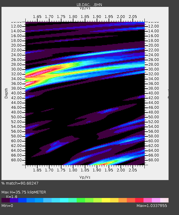
| Estimated Moho Depth: |
35.75 km |
| Estimated Crust Vp/Vs: |
1.60 |
| Assumed Crust Vp: |
6.279 km/s |
| Estimated Crust Vs: |
3.924 km/s |
| Estimated Crust Poisson's Ratio: |
0.18 |
|
| Radial Match: |
90.68247 % |
| Radial Bump: |
317 |
| Transverse Match: |
73.21938 % |
| Transverse Bump: |
370 |
| SOD ConfigId: |
469095 |
| Insert Time: |
2013-02-22 03:06:20.403 +0000 |
| GWidth: |
2.5 |
| Max Bumps: |
400 |
| Tol: |
0.001 |
|

Signal To Noise
| Channel | StoN | STA | LTA |
| LB:DAC: :BHZ:20120802T09:47:53.310999Z | 15.226502 | 9.251835E-7 | 6.0761394E-8 |
| LB:DAC: :BHN:20120802T09:47:53.310999Z | 3.2784195 | 2.0648525E-7 | 6.298317E-8 |
| LB:DAC: :BHE:20120802T09:47:53.310999Z | 6.086358 | 3.9819324E-7 | 6.54239E-8 |
| Arrivals |
| Ps | 3.6 SECOND |
| PpPs | 14 SECOND |
| PsPs/PpSs | 18 SECOND |


