You are here: Home > Network List > LD - Lamont-Doherty Cooperative Seismographic Network Stations List
> Station KSPA Keystone College, La Plume, PA > Earthquake Result Viewer
KSPA Keystone College, La Plume, PA - Earthquake Result Viewer
| Earthquake location: |
Peru-Brazil Border Region |
| Earthquake latitude/longitude: |
-8.4/-74.3 |
| Earthquake time(UTC): |
2012/08/02 (215) 09:38:30 GMT |
| Earthquake Depth: |
145 km |
| Earthquake Magnitude: |
5.9 MB, 6.1 MW, 6.1 MW |
| Earthquake Catalog/Contributor: |
WHDF/NEIC |
|
| Network: |
LD Lamont-Doherty Cooperative Seismographic Network |
| Station: |
KSPA Keystone College, La Plume, PA |
| Lat/Lon: |
41.56 N/75.77 W |
| Elevation: |
298 m |
|
| Distance: |
49.7 deg |
| Az: |
358.516 deg |
| Baz: |
178.043 deg |
| Ray Param: |
0.068003744 |
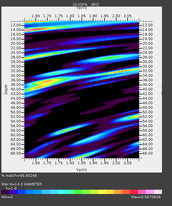
| Estimated Moho Depth: |
14.0 km |
| Estimated Crust Vp/Vs: |
1.60 |
| Assumed Crust Vp: |
6.283 km/s |
| Estimated Crust Vs: |
3.927 km/s |
| Estimated Crust Poisson's Ratio: |
0.18 |
|
| Radial Match: |
86.88249 % |
| Radial Bump: |
400 |
| Transverse Match: |
69.60053 % |
| Transverse Bump: |
400 |
| SOD ConfigId: |
469095 |
| Insert Time: |
2013-02-22 03:07:32.014 +0000 |
| GWidth: |
2.5 |
| Max Bumps: |
400 |
| Tol: |
0.001 |
|

Signal To Noise
| Channel | StoN | STA | LTA |
| LD:KSPA: :BHZ:20120802T09:46:37.915002Z | 9.611727 | 1.2804974E-6 | 1.332224E-7 |
| LD:KSPA: :BHN:20120802T09:46:37.915002Z | 8.201715 | 5.092326E-7 | 6.2088546E-8 |
| LD:KSPA: :BHE:20120802T09:46:37.915002Z | 1.7412513 | 1.4513462E-7 | 8.335076E-8 |
| Arrivals |
| Ps | 1.4 SECOND |
| PpPs | 5.4 SECOND |
| PsPs/PpSs | 6.9 SECOND |


