You are here: Home > Network List > NE - New England Seismic Network Stations List
> Station VT1 Waterbury, VT, USA > Earthquake Result Viewer
VT1 Waterbury, VT, USA - Earthquake Result Viewer
| Earthquake location: |
Peru-Brazil Border Region |
| Earthquake latitude/longitude: |
-8.4/-74.3 |
| Earthquake time(UTC): |
2012/08/02 (215) 09:38:30 GMT |
| Earthquake Depth: |
145 km |
| Earthquake Magnitude: |
5.9 MB, 6.1 MW, 6.1 MW |
| Earthquake Catalog/Contributor: |
WHDF/NEIC |
|
| Network: |
NE New England Seismic Network |
| Station: |
VT1 Waterbury, VT, USA |
| Lat/Lon: |
44.32 N/72.75 W |
| Elevation: |
149 m |
|
| Distance: |
52.5 deg |
| Az: |
1.364 deg |
| Baz: |
181.88 deg |
| Ray Param: |
0.0662259 |
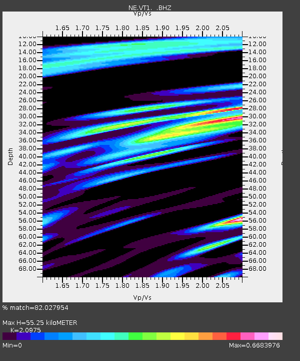
| Estimated Moho Depth: |
55.25 km |
| Estimated Crust Vp/Vs: |
2.10 |
| Assumed Crust Vp: |
6.419 km/s |
| Estimated Crust Vs: |
3.06 km/s |
| Estimated Crust Poisson's Ratio: |
0.35 |
|
| Radial Match: |
82.027954 % |
| Radial Bump: |
368 |
| Transverse Match: |
78.6015 % |
| Transverse Bump: |
400 |
| SOD ConfigId: |
469095 |
| Insert Time: |
2013-02-22 03:08:48.554 +0000 |
| GWidth: |
2.5 |
| Max Bumps: |
400 |
| Tol: |
0.001 |
|

Signal To Noise
| Channel | StoN | STA | LTA |
| NE:VT1: :BHZ:20120802T09:46:58.450006Z | 6.129374 | 7.846811E-7 | 1.2801976E-7 |
| NE:VT1: :BHN:20120802T09:46:58.450006Z | 3.5533435 | 4.356846E-7 | 1.2261258E-7 |
| NE:VT1: :BHE:20120802T09:46:58.450006Z | 2.3443937 | 2.77327E-7 | 1.18293684E-7 |
| Arrivals |
| Ps | 9.9 SECOND |
| PpPs | 25 SECOND |
| PsPs/PpSs | 35 SECOND |


