You are here: Home > Network List > PE - Penn State Network Stations List
> Station PSWB Penn State Wilkes-Barre > Earthquake Result Viewer
PSWB Penn State Wilkes-Barre - Earthquake Result Viewer
| Earthquake location: |
Peru-Brazil Border Region |
| Earthquake latitude/longitude: |
-8.4/-74.3 |
| Earthquake time(UTC): |
2012/08/02 (215) 09:38:30 GMT |
| Earthquake Depth: |
145 km |
| Earthquake Magnitude: |
5.9 MB, 6.1 MW, 6.1 MW |
| Earthquake Catalog/Contributor: |
WHDF/NEIC |
|
| Network: |
PE Penn State Network |
| Station: |
PSWB Penn State Wilkes-Barre |
| Lat/Lon: |
41.31 N/76.02 W |
| Elevation: |
398 m |
|
| Distance: |
49.5 deg |
| Az: |
358.26 deg |
| Baz: |
177.715 deg |
| Ray Param: |
0.06816588 |
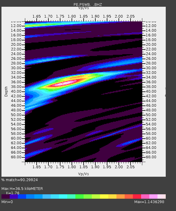
| Estimated Moho Depth: |
36.5 km |
| Estimated Crust Vp/Vs: |
1.76 |
| Assumed Crust Vp: |
6.121 km/s |
| Estimated Crust Vs: |
3.478 km/s |
| Estimated Crust Poisson's Ratio: |
0.26 |
|
| Radial Match: |
90.29924 % |
| Radial Bump: |
345 |
| Transverse Match: |
68.42432 % |
| Transverse Bump: |
400 |
| SOD ConfigId: |
469095 |
| Insert Time: |
2013-02-22 03:10:18.788 +0000 |
| GWidth: |
2.5 |
| Max Bumps: |
400 |
| Tol: |
0.001 |
|

Signal To Noise
| Channel | StoN | STA | LTA |
| PE:PSWB: :BHZ:20120802T09:46:36.059991Z | 18.599201 | 1.5237825E-6 | 8.192731E-8 |
| PE:PSWB: :BHN:20120802T09:46:36.059991Z | 7.528311 | 6.7360537E-7 | 8.9476295E-8 |
| PE:PSWB: :BHE:20120802T09:46:36.059991Z | 2.7285464 | 2.1731299E-7 | 7.964423E-8 |
| Arrivals |
| Ps | 4.8 SECOND |
| PpPs | 16 SECOND |
| PsPs/PpSs | 20 SECOND |


