You are here: Home > Network List > TA - USArray Transportable Network (new EarthScope stations) Stations List
> Station R11A Troy Canyon, Currant, NV, USA > Earthquake Result Viewer
R11A Troy Canyon, Currant, NV, USA - Earthquake Result Viewer

| Earthquake location: |
Peru-Brazil Border Region |
| Earthquake latitude/longitude: |
-8.4/-74.3 |
| Earthquake time(UTC): |
2012/08/02 (215) 09:38:30 GMT |
| Earthquake Depth: |
145 km |
| Earthquake Magnitude: |
5.9 MB, 6.1 MW, 6.1 MW |
| Earthquake Catalog/Contributor: |
WHDF/NEIC |
|
| Network: |
TA USArray Transportable Network (new EarthScope stations) |
| Station: |
R11A Troy Canyon, Currant, NV, USA |
| Lat/Lon: |
38.35 N/115.59 W |
| Elevation: |
1756 m |
|
| Distance: |
60.4 deg |
| Az: |
323.323 deg |
| Baz: |
131.271 deg |
| Ray Param: |
0.061133277 |
| Estimated Moho Depth: |
33.75 km |
| Estimated Crust Vp/Vs: |
1.69 |
| Assumed Crust Vp: |
6.276 km/s |
| Estimated Crust Vs: |
3.725 km/s |
| Estimated Crust Poisson's Ratio: |
0.23 |
|
| Radial Match: |
95.18401 % |
| Radial Bump: |
314 |
| Transverse Match: |
89.03287 % |
| Transverse Bump: |
400 |
| SOD ConfigId: |
469095 |
| Insert Time: |
2013-02-22 03:11:17.543 +0000 |
| GWidth: |
2.5 |
| Max Bumps: |
400 |
| Tol: |
0.001 |
|
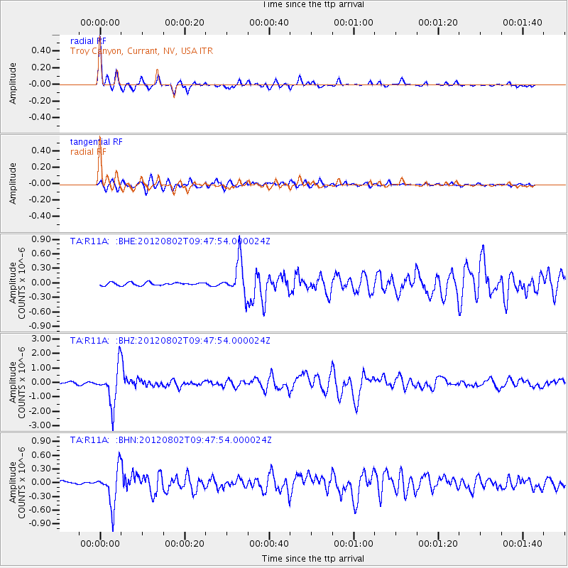
Signal To Noise
| Channel | StoN | STA | LTA |
| TA:R11A: :BHZ:20120802T09:47:54.000024Z | 24.138182 | 1.3235607E-6 | 5.483266E-8 |
| TA:R11A: :BHN:20120802T09:47:54.000024Z | 11.032323 | 4.0337824E-7 | 3.656331E-8 |
| TA:R11A: :BHE:20120802T09:47:54.000024Z | 11.913648 | 3.6588656E-7 | 3.071155E-8 |
| Arrivals |
| Ps | 3.9 SECOND |
| PpPs | 14 SECOND |
| PsPs/PpSs | 18 SECOND |


