You are here: Home > Network List > TA - USArray Transportable Network (new EarthScope stations) Stations List
> Station H17A Grant Village (NPS), Yellowstone Nt. Park, WY, USA > Earthquake Result Viewer
H17A Grant Village (NPS), Yellowstone Nt. Park, WY, USA - Earthquake Result Viewer

| Earthquake location: |
Peru-Brazil Border Region |
| Earthquake latitude/longitude: |
-8.4/-74.3 |
| Earthquake time(UTC): |
2012/08/02 (215) 09:38:30 GMT |
| Earthquake Depth: |
145 km |
| Earthquake Magnitude: |
5.9 MB, 6.1 MW, 6.1 MW |
| Earthquake Catalog/Contributor: |
WHDF/NEIC |
|
| Network: |
TA USArray Transportable Network (new EarthScope stations) |
| Station: |
H17A Grant Village (NPS), Yellowstone Nt. Park, WY, USA |
| Lat/Lon: |
44.40 N/110.58 W |
| Elevation: |
2400 m |
|
| Distance: |
62.0 deg |
| Az: |
331.246 deg |
| Baz: |
138.401 deg |
| Ray Param: |
0.06011205 |
| Estimated Moho Depth: |
20.25 km |
| Estimated Crust Vp/Vs: |
1.82 |
| Assumed Crust Vp: |
6.35 km/s |
| Estimated Crust Vs: |
3.489 km/s |
| Estimated Crust Poisson's Ratio: |
0.28 |
|
| Radial Match: |
86.50015 % |
| Radial Bump: |
400 |
| Transverse Match: |
88.950836 % |
| Transverse Bump: |
400 |
| SOD ConfigId: |
469095 |
| Insert Time: |
2013-02-22 03:11:31.705 +0000 |
| GWidth: |
2.5 |
| Max Bumps: |
400 |
| Tol: |
0.001 |
|
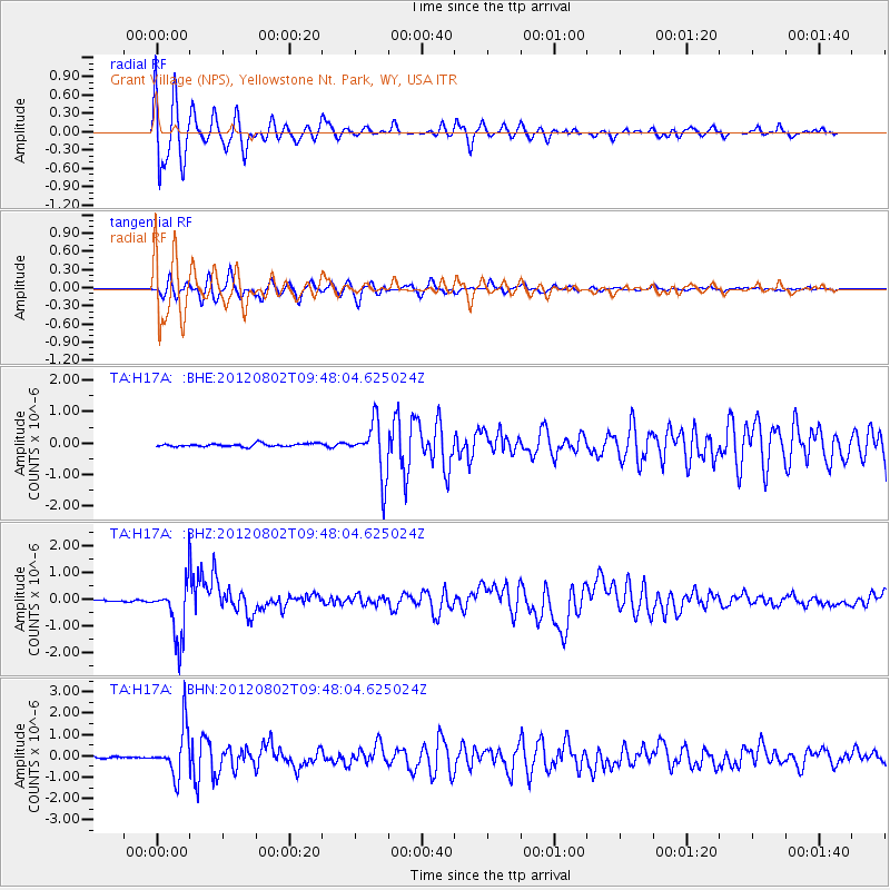
Signal To Noise
| Channel | StoN | STA | LTA |
| TA:H17A: :BHZ:20120802T09:48:04.625024Z | 26.428167 | 1.0529106E-6 | 3.984047E-8 |
| TA:H17A: :BHN:20120802T09:48:04.625024Z | 34.19114 | 1.1108702E-6 | 3.2490004E-8 |
| TA:H17A: :BHE:20120802T09:48:04.625024Z | 17.99997 | 8.534509E-7 | 4.741402E-8 |
| Arrivals |
| Ps | 2.7 SECOND |
| PpPs | 8.6 SECOND |
| PsPs/PpSs | 11 SECOND |


