You are here: Home > Network List > TA - USArray Transportable Network (new EarthScope stations) Stations List
> Station S22A 4UR Ranch, Creede, CO, USA > Earthquake Result Viewer
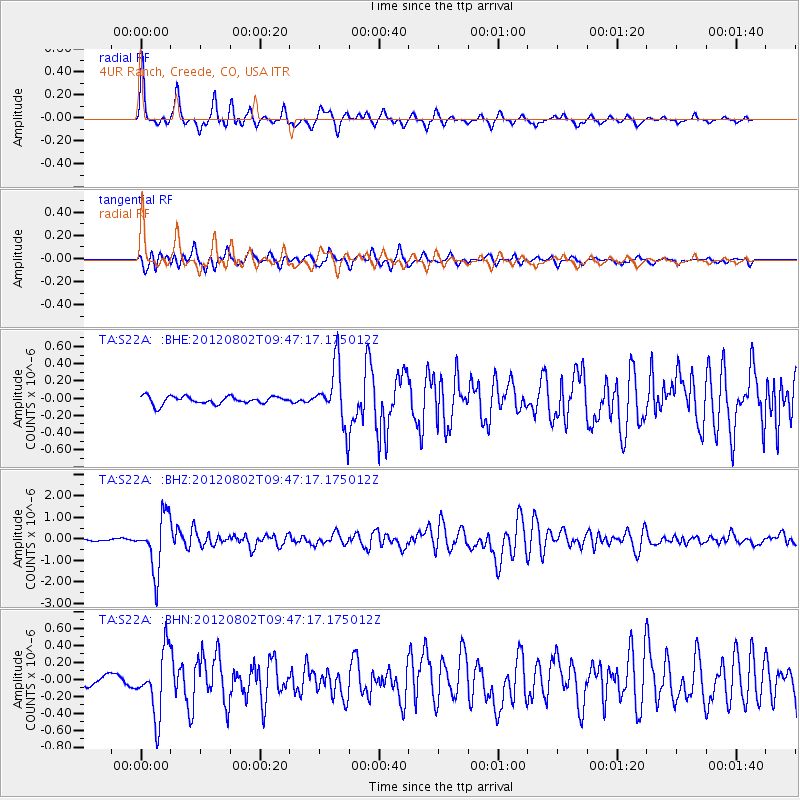
S22A 4UR Ranch, Creede, CO, USA - Earthquake Result Viewer

| Earthquake location: |
Peru-Brazil Border Region |
| Earthquake latitude/longitude: |
-8.4/-74.3 |
| Earthquake time(UTC): |
2012/08/02 (215) 09:38:30 GMT |
| Earthquake Depth: |
145 km |
| Earthquake Magnitude: |
5.9 MB, 6.1 MW, 6.1 MW |
| Earthquake Catalog/Contributor: |
WHDF/NEIC |
|
| Network: |
TA USArray Transportable Network (new EarthScope stations) |
| Station: |
S22A 4UR Ranch, Creede, CO, USA |
| Lat/Lon: |
37.75 N/106.83 W |
| Elevation: |
2626 m |
|
| Distance: |
55.1 deg |
| Az: |
328.64 deg |
| Baz: |
139.495 deg |
| Ray Param: |
0.06455309 |
| Estimated Moho Depth: |
48.75 km |
| Estimated Crust Vp/Vs: |
1.73 |
| Assumed Crust Vp: |
6.159 km/s |
| Estimated Crust Vs: |
3.555 km/s |
| Estimated Crust Poisson's Ratio: |
0.25 |
|
| Radial Match: |
93.37499 % |
| Radial Bump: |
400 |
| Transverse Match: |
84.79245 % |
| Transverse Bump: |
400 |
| SOD ConfigId: |
469095 |
| Insert Time: |
2013-02-22 03:11:55.059 +0000 |
| GWidth: |
2.5 |
| Max Bumps: |
400 |
| Tol: |
0.001 |
|
Signal To Noise
| Channel | StoN | STA | LTA |
| TA:S22A: :BHZ:20120802T09:47:17.175012Z | 20.517977 | 1.2596926E-6 | 6.139458E-8 |
| TA:S22A: :BHN:20120802T09:47:17.175012Z | 7.4206667 | 3.7612008E-7 | 5.0685482E-8 |
| TA:S22A: :BHE:20120802T09:47:17.175012Z | 7.5416665 | 3.4221472E-7 | 4.537654E-8 |
| Arrivals |
| Ps | 6.1 SECOND |
| PpPs | 21 SECOND |
| PsPs/PpSs | 27 SECOND |


