You are here: Home > Network List > TA - USArray Transportable Network (new EarthScope stations) Stations List
> Station TIGA Tifton, GA, USA > Earthquake Result Viewer
TIGA Tifton, GA, USA - Earthquake Result Viewer
| Earthquake location: |
Peru-Brazil Border Region |
| Earthquake latitude/longitude: |
-8.4/-74.3 |
| Earthquake time(UTC): |
2012/08/02 (215) 09:38:30 GMT |
| Earthquake Depth: |
145 km |
| Earthquake Magnitude: |
5.9 MB, 6.1 MW, 6.1 MW |
| Earthquake Catalog/Contributor: |
WHDF/NEIC |
|
| Network: |
TA USArray Transportable Network (new EarthScope stations) |
| Station: |
TIGA Tifton, GA, USA |
| Lat/Lon: |
31.44 N/83.59 W |
| Elevation: |
109 m |
|
| Distance: |
40.6 deg |
| Az: |
347.71 deg |
| Baz: |
165.736 deg |
| Ray Param: |
0.07375723 |
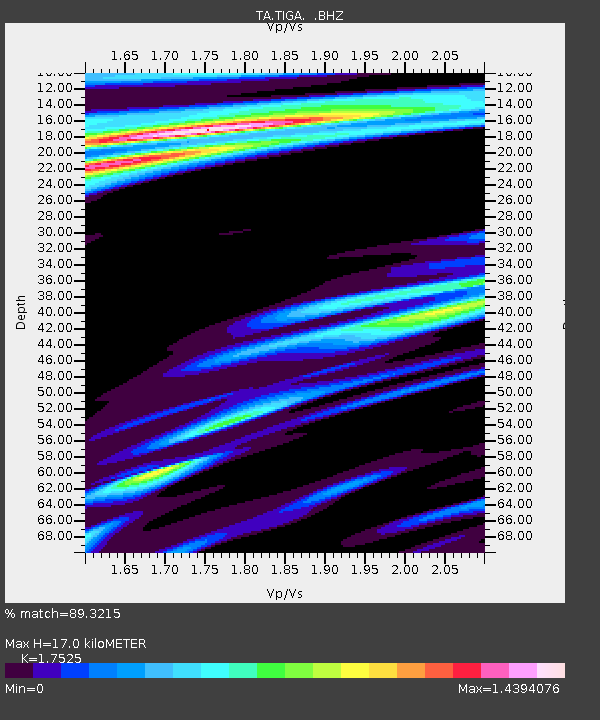
| Estimated Moho Depth: |
17.0 km |
| Estimated Crust Vp/Vs: |
1.75 |
| Assumed Crust Vp: |
6.565 km/s |
| Estimated Crust Vs: |
3.746 km/s |
| Estimated Crust Poisson's Ratio: |
0.26 |
|
| Radial Match: |
89.3215 % |
| Radial Bump: |
400 |
| Transverse Match: |
62.900555 % |
| Transverse Bump: |
400 |
| SOD ConfigId: |
469095 |
| Insert Time: |
2013-02-22 03:13:01.974 +0000 |
| GWidth: |
2.5 |
| Max Bumps: |
400 |
| Tol: |
0.001 |
|

Signal To Noise
| Channel | StoN | STA | LTA |
| TA:TIGA: :BHZ:20120802T09:45:26.124994Z | 7.3519096 | 1.5181898E-6 | 2.0650279E-7 |
| TA:TIGA: :BHN:20120802T09:45:26.124994Z | 5.845509 | 7.911526E-7 | 1.3534367E-7 |
| TA:TIGA: :BHE:20120802T09:45:26.124994Z | 1.4643648 | 3.3841647E-7 | 2.3110121E-7 |
| Arrivals |
| Ps | 2.1 SECOND |
| PpPs | 6.6 SECOND |
| PsPs/PpSs | 8.7 SECOND |


