You are here: Home > Network List > TA - USArray Transportable Network (new EarthScope stations) Stations List
> Station K04D Chiloquin, OR, USA > Earthquake Result Viewer
K04D Chiloquin, OR, USA - Earthquake Result Viewer
| Earthquake location: |
Peru-Brazil Border Region |
| Earthquake latitude/longitude: |
-8.4/-74.3 |
| Earthquake time(UTC): |
2012/08/02 (215) 09:38:30 GMT |
| Earthquake Depth: |
145 km |
| Earthquake Magnitude: |
5.9 MB, 6.1 MW, 6.1 MW |
| Earthquake Catalog/Contributor: |
WHDF/NEIC |
|
| Network: |
TA USArray Transportable Network (new EarthScope stations) |
| Station: |
K04D Chiloquin, OR, USA |
| Lat/Lon: |
42.62 N/121.75 W |
| Elevation: |
1315 m |
|
| Distance: |
66.7 deg |
| Az: |
323.675 deg |
| Baz: |
127.434 deg |
| Ray Param: |
0.057028465 |
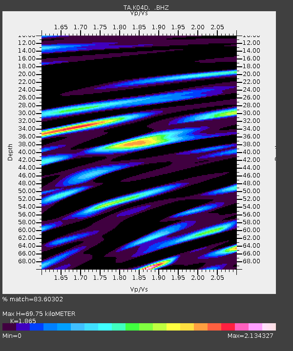
| Estimated Moho Depth: |
69.75 km |
| Estimated Crust Vp/Vs: |
1.87 |
| Assumed Crust Vp: |
6.597 km/s |
| Estimated Crust Vs: |
3.538 km/s |
| Estimated Crust Poisson's Ratio: |
0.30 |
|
| Radial Match: |
83.60302 % |
| Radial Bump: |
400 |
| Transverse Match: |
71.69522 % |
| Transverse Bump: |
400 |
| SOD ConfigId: |
469095 |
| Insert Time: |
2013-02-22 03:13:14.446 +0000 |
| GWidth: |
2.5 |
| Max Bumps: |
400 |
| Tol: |
0.001 |
|
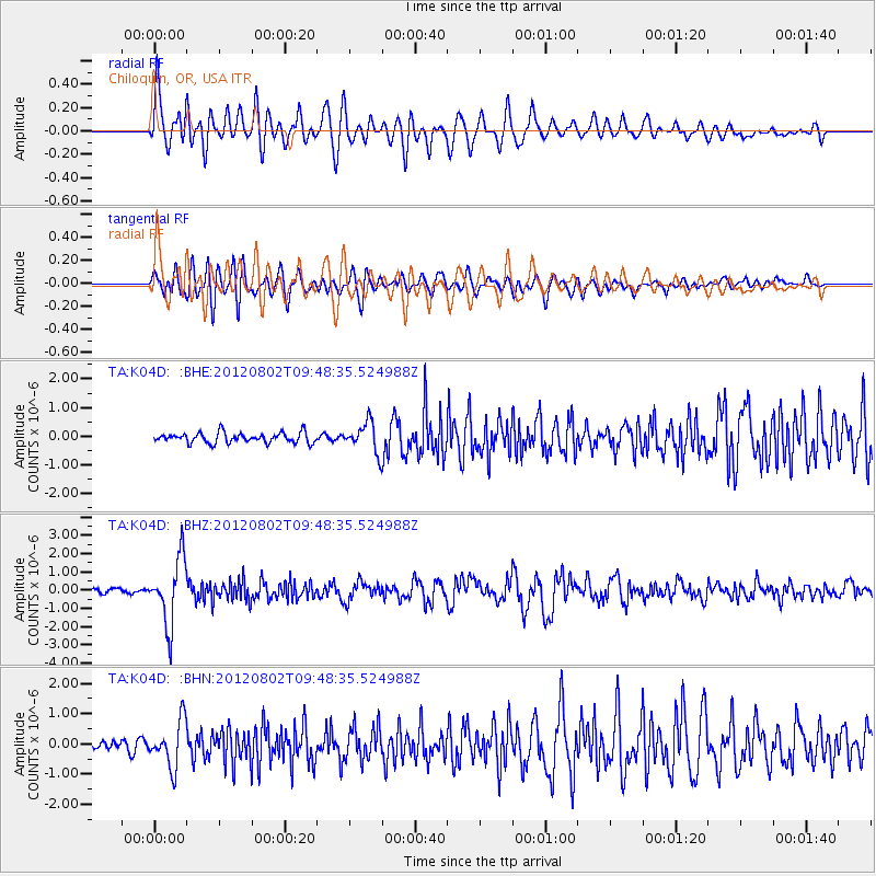
Signal To Noise
| Channel | StoN | STA | LTA |
| TA:K04D: :BHZ:20120802T09:48:35.524988Z | 16.246881 | 1.7872121E-6 | 1.10003384E-7 |
| TA:K04D: :BHN:20120802T09:48:35.524988Z | 4.1117706 | 7.540537E-7 | 1.8338905E-7 |
| TA:K04D: :BHE:20120802T09:48:35.524988Z | 2.9567719 | 5.219626E-7 | 1.7653124E-7 |
| Arrivals |
| Ps | 9.5 SECOND |
| PpPs | 29 SECOND |
| PsPs/PpSs | 39 SECOND |


