You are here: Home > Network List > TA - USArray Transportable Network (new EarthScope stations) Stations List
> Station TPFO Pinon Flats, CA, USA > Earthquake Result Viewer
TPFO Pinon Flats, CA, USA - Earthquake Result Viewer
| Earthquake location: |
Peru-Brazil Border Region |
| Earthquake latitude/longitude: |
-8.4/-74.3 |
| Earthquake time(UTC): |
2012/08/02 (215) 09:38:30 GMT |
| Earthquake Depth: |
145 km |
| Earthquake Magnitude: |
5.9 MB, 6.1 MW, 6.1 MW |
| Earthquake Catalog/Contributor: |
WHDF/NEIC |
|
| Network: |
TA USArray Transportable Network (new EarthScope stations) |
| Station: |
TPFO Pinon Flats, CA, USA |
| Lat/Lon: |
33.61 N/116.45 W |
| Elevation: |
1275 m |
|
| Distance: |
57.9 deg |
| Az: |
318.56 deg |
| Baz: |
128.317 deg |
| Ray Param: |
0.06275433 |
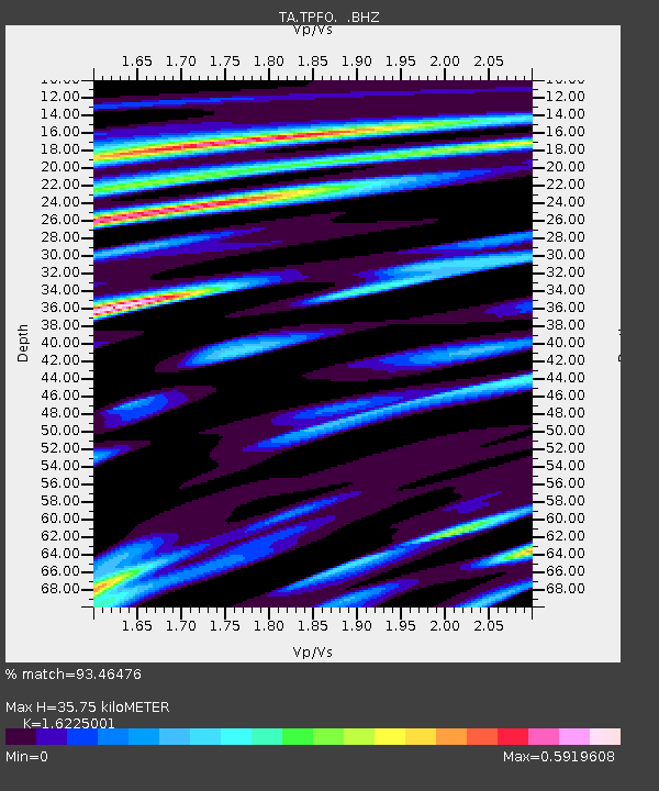
| Estimated Moho Depth: |
35.75 km |
| Estimated Crust Vp/Vs: |
1.62 |
| Assumed Crust Vp: |
6.264 km/s |
| Estimated Crust Vs: |
3.86 km/s |
| Estimated Crust Poisson's Ratio: |
0.19 |
|
| Radial Match: |
93.46476 % |
| Radial Bump: |
400 |
| Transverse Match: |
85.18902 % |
| Transverse Bump: |
400 |
| SOD ConfigId: |
469095 |
| Insert Time: |
2013-02-22 03:14:16.584 +0000 |
| GWidth: |
2.5 |
| Max Bumps: |
400 |
| Tol: |
0.001 |
|
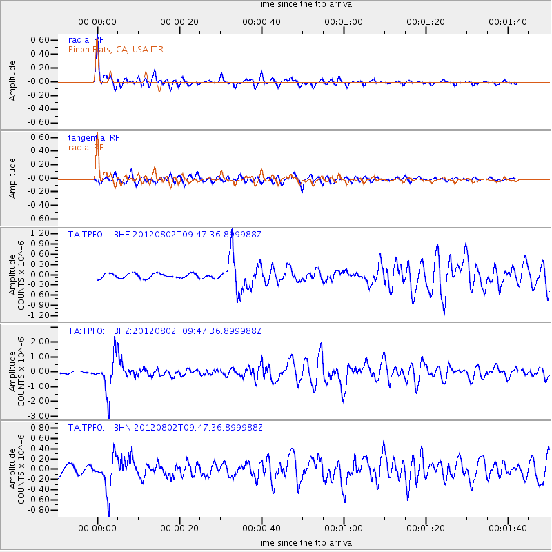
Signal To Noise
| Channel | StoN | STA | LTA |
| TA:TPFO: :BHZ:20120802T09:47:36.899988Z | 23.556856 | 1.2310195E-6 | 5.2257377E-8 |
| TA:TPFO: :BHN:20120802T09:47:36.899988Z | 3.9812434 | 3.399943E-7 | 8.539903E-8 |
| TA:TPFO: :BHE:20120802T09:47:36.899988Z | 7.416925 | 5.1985404E-7 | 7.009024E-8 |
| Arrivals |
| Ps | 3.7 SECOND |
| PpPs | 14 SECOND |
| PsPs/PpSs | 18 SECOND |


