You are here: Home > Network List > TA - USArray Transportable Network (new EarthScope stations) Stations List
> Station H04D Lebanon, OR, USA > Earthquake Result Viewer
H04D Lebanon, OR, USA - Earthquake Result Viewer

| Earthquake location: |
Peru-Brazil Border Region |
| Earthquake latitude/longitude: |
-8.4/-74.3 |
| Earthquake time(UTC): |
2012/08/02 (215) 09:38:30 GMT |
| Earthquake Depth: |
145 km |
| Earthquake Magnitude: |
5.9 MB, 6.1 MW, 6.1 MW |
| Earthquake Catalog/Contributor: |
WHDF/NEIC |
|
| Network: |
TA USArray Transportable Network (new EarthScope stations) |
| Station: |
H04D Lebanon, OR, USA |
| Lat/Lon: |
44.52 N/122.74 W |
| Elevation: |
284 m |
|
| Distance: |
68.4 deg |
| Az: |
324.839 deg |
| Baz: |
127.202 deg |
| Ray Param: |
0.0559151 |
| Estimated Moho Depth: |
43.5 km |
| Estimated Crust Vp/Vs: |
2.10 |
| Assumed Crust Vp: |
6.566 km/s |
| Estimated Crust Vs: |
3.13 km/s |
| Estimated Crust Poisson's Ratio: |
0.35 |
|
| Radial Match: |
81.97232 % |
| Radial Bump: |
400 |
| Transverse Match: |
70.75293 % |
| Transverse Bump: |
400 |
| SOD ConfigId: |
469095 |
| Insert Time: |
2013-02-22 03:14:52.121 +0000 |
| GWidth: |
2.5 |
| Max Bumps: |
400 |
| Tol: |
0.001 |
|
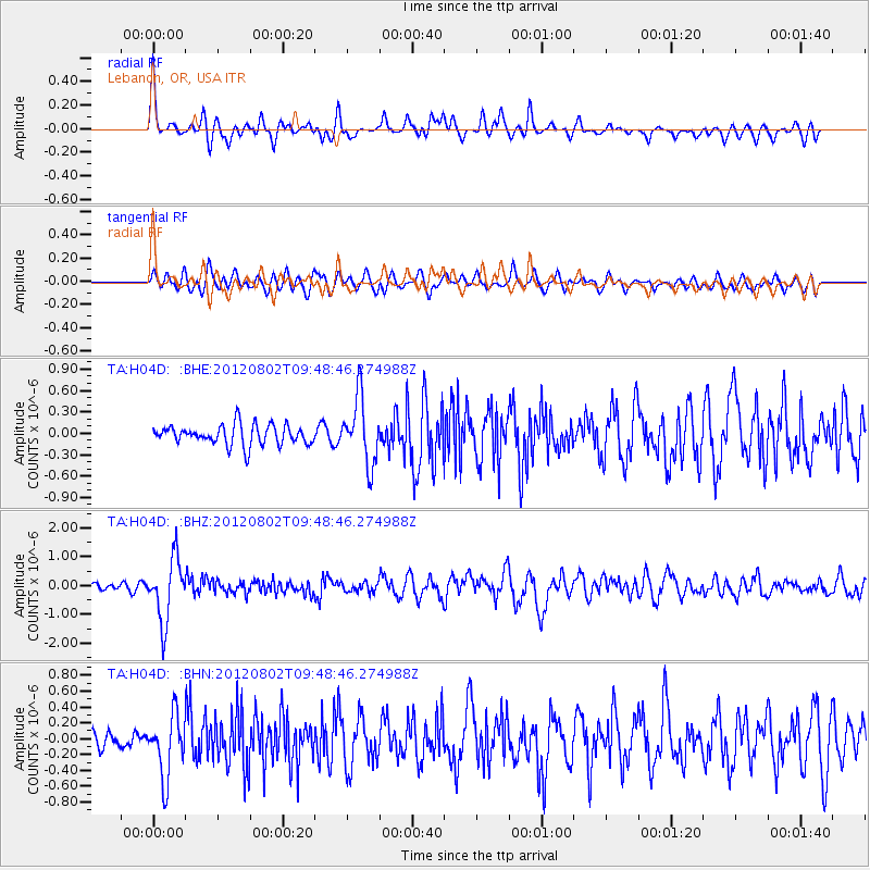
Signal To Noise
| Channel | StoN | STA | LTA |
| TA:H04D: :BHZ:20120802T09:48:46.274988Z | 11.603271 | 1.0890489E-6 | 9.3857054E-8 |
| TA:H04D: :BHN:20120802T09:48:46.274988Z | 3.668912 | 3.912736E-7 | 1.0664567E-7 |
| TA:H04D: :BHE:20120802T09:48:46.274988Z | 3.2630093 | 4.5769377E-7 | 1.4026737E-7 |
| Arrivals |
| Ps | 7.5 SECOND |
| PpPs | 20 SECOND |
| PsPs/PpSs | 27 SECOND |


