You are here: Home > Network List > TA - USArray Transportable Network (new EarthScope stations) Stations List
> Station A04D Lummi Island, WA, USA > Earthquake Result Viewer
A04D Lummi Island, WA, USA - Earthquake Result Viewer

| Earthquake location: |
Peru-Brazil Border Region |
| Earthquake latitude/longitude: |
-8.4/-74.3 |
| Earthquake time(UTC): |
2012/08/02 (215) 09:38:30 GMT |
| Earthquake Depth: |
145 km |
| Earthquake Magnitude: |
5.9 MB, 6.1 MW, 6.1 MW |
| Earthquake Catalog/Contributor: |
WHDF/NEIC |
|
| Network: |
TA USArray Transportable Network (new EarthScope stations) |
| Station: |
A04D Lummi Island, WA, USA |
| Lat/Lon: |
48.72 N/122.71 W |
| Elevation: |
13 m |
|
| Distance: |
71.0 deg |
| Az: |
328.388 deg |
| Baz: |
128.456 deg |
| Ray Param: |
0.054240976 |
| Estimated Moho Depth: |
34.0 km |
| Estimated Crust Vp/Vs: |
2.01 |
| Assumed Crust Vp: |
6.566 km/s |
| Estimated Crust Vs: |
3.267 km/s |
| Estimated Crust Poisson's Ratio: |
0.34 |
|
| Radial Match: |
88.14298 % |
| Radial Bump: |
400 |
| Transverse Match: |
78.866135 % |
| Transverse Bump: |
400 |
| SOD ConfigId: |
469095 |
| Insert Time: |
2013-02-22 03:15:03.842 +0000 |
| GWidth: |
2.5 |
| Max Bumps: |
400 |
| Tol: |
0.001 |
|
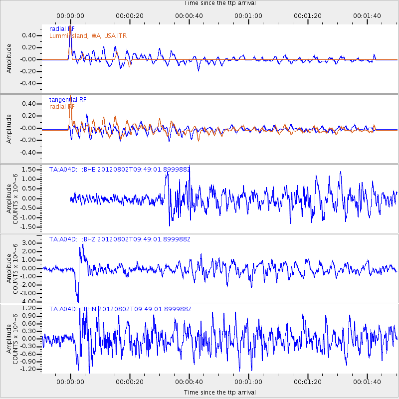
Signal To Noise
| Channel | StoN | STA | LTA |
| TA:A04D: :BHZ:20120802T09:49:01.899988Z | 15.215376 | 1.7821343E-6 | 1.1712719E-7 |
| TA:A04D: :BHN:20120802T09:49:01.899988Z | 3.570656 | 5.265729E-7 | 1.474723E-7 |
| TA:A04D: :BHE:20120802T09:49:01.899988Z | 5.392816 | 7.2348325E-7 | 1.3415685E-7 |
| Arrivals |
| Ps | 5.4 SECOND |
| PpPs | 15 SECOND |
| PsPs/PpSs | 20 SECOND |


