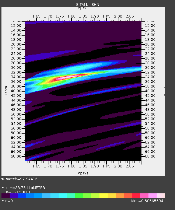
TAM Tamanrasset, Algeria - Earthquake Result Viewer

Earthquake location: Off Coast Of Northern Peru
Earthquake latitude/longitude: -9.6/-79.6
Earthquake time(UTC): 1996/02/21 (052) 12:51:04 GMT
Earthquake Depth: 33 km
Earthquake Magnitude: 5.8 MB, 6.6 MS, 7.5 UNKNOWN, 7.3 MW
Earthquake Catalog/Contributor: WHDF/NEIC
Network: G GEOSCOPE
Station: TAM Tamanrasset, Algeria
Lat/Lon: 22.79 N/5.53 E
Elevation: 1377 m
Distance: 89.2 deg
Az: 66.861 deg
Baz: 259.297 deg
Ray Param: 0.041978616
Estimated Moho Depth: 33.75 km
Estimated Crust Vp/Vs: 1.79
Assumed Crust Vp: 6.61 km/s
Estimated Crust Vs: 3.703 km/s
Estimated Crust Poisson's Ratio: 0.27
Radial Match: 97.94416 %
Radial Bump: 243
Transverse Match: 84.18247 %
Transverse Bump: 400
SOD ConfigId: 6273
Insert Time: 2010-02-27 00:29:17.409 +0000
GWidth: 2.5
Max Bumps: 400
Tol: 0.001

Signal To Noise

ChannelStoNSTALTA
G:TAM: :BHN:19960221T13:03:25.500012Z0.94943446.642139E-86.995891E-8
G:TAM: :BHE:19960221T13:03:25.500012Z2.81789682.0250194E-77.186279E-8
G:TAM: :BHZ:19960221T13:03:25.500012Z5.9824287.045228E-71.1776535E-7
Arrivals
Ps4.1 SECOND
PpPs14 SECOND
PsPs/PpSs18 SECOND