You are here: Home > Network List > TA - USArray Transportable Network (new EarthScope stations) Stations List
> Station N54A Moraine State Park, Portersville, PA, USA > Earthquake Result Viewer
N54A Moraine State Park, Portersville, PA, USA - Earthquake Result Viewer
| Earthquake location: |
Peru-Brazil Border Region |
| Earthquake latitude/longitude: |
-8.4/-74.3 |
| Earthquake time(UTC): |
2012/08/02 (215) 09:38:30 GMT |
| Earthquake Depth: |
145 km |
| Earthquake Magnitude: |
5.9 MB, 6.1 MW, 6.1 MW |
| Earthquake Catalog/Contributor: |
WHDF/NEIC |
|
| Network: |
TA USArray Transportable Network (new EarthScope stations) |
| Station: |
N54A Moraine State Park, Portersville, PA, USA |
| Lat/Lon: |
40.96 N/79.99 W |
| Elevation: |
408 m |
|
| Distance: |
49.4 deg |
| Az: |
354.286 deg |
| Baz: |
172.526 deg |
| Ray Param: |
0.06822187 |
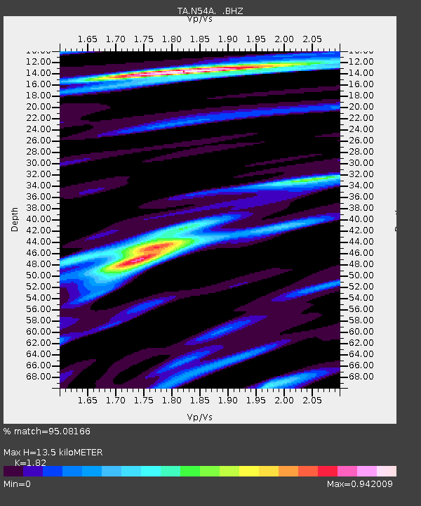
| Estimated Moho Depth: |
13.5 km |
| Estimated Crust Vp/Vs: |
1.82 |
| Assumed Crust Vp: |
6.121 km/s |
| Estimated Crust Vs: |
3.363 km/s |
| Estimated Crust Poisson's Ratio: |
0.28 |
|
| Radial Match: |
95.08166 % |
| Radial Bump: |
400 |
| Transverse Match: |
75.94204 % |
| Transverse Bump: |
400 |
| SOD ConfigId: |
469095 |
| Insert Time: |
2013-02-22 03:17:44.710 +0000 |
| GWidth: |
2.5 |
| Max Bumps: |
400 |
| Tol: |
0.001 |
|
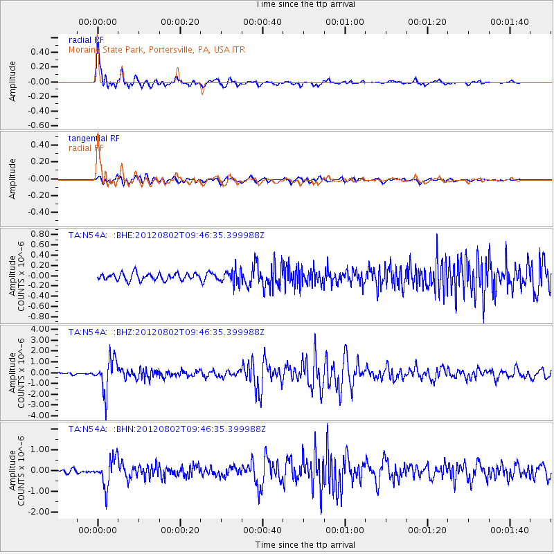
Signal To Noise
| Channel | StoN | STA | LTA |
| TA:N54A: :BHZ:20120802T09:46:35.399988Z | 13.52107 | 1.5169552E-6 | 1.12191955E-7 |
| TA:N54A: :BHN:20120802T09:46:35.399988Z | 10.749501 | 6.792965E-7 | 6.3193305E-8 |
| TA:N54A: :BHE:20120802T09:46:35.399988Z | 1.94306 | 1.2938315E-7 | 6.658731E-8 |
| Arrivals |
| Ps | 1.9 SECOND |
| PpPs | 5.9 SECOND |
| PsPs/PpSs | 7.8 SECOND |


