You are here: Home > Network List > G - GEOSCOPE Stations List
> Station TAM Tamanrasset, Algeria > Earthquake Result Viewer
TAM Tamanrasset, Algeria - Earthquake Result Viewer
| Earthquake location: |
Yunnan, China |
| Earthquake latitude/longitude: |
27.3/100.3 |
| Earthquake time(UTC): |
1996/02/03 (034) 11:14:19 GMT |
| Earthquake Depth: |
10 km |
| Earthquake Magnitude: |
6.3 MB, 6.5 MS, 6.6 UNKNOWN, 6.6 ME |
| Earthquake Catalog/Contributor: |
WHDF/NEIC |
|
| Network: |
G GEOSCOPE |
| Station: |
TAM Tamanrasset, Algeria |
| Lat/Lon: |
22.79 N/5.53 E |
| Elevation: |
1377 m |
|
| Distance: |
83.9 deg |
| Az: |
292.349 deg |
| Baz: |
63.105 deg |
| Ray Param: |
0.04588086 |
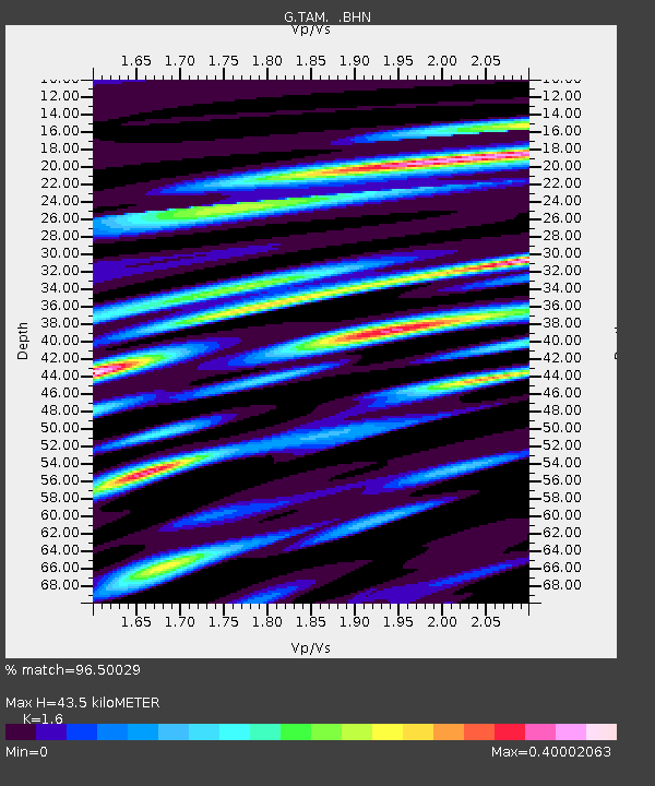
| Estimated Moho Depth: |
43.5 km |
| Estimated Crust Vp/Vs: |
1.60 |
| Assumed Crust Vp: |
6.61 km/s |
| Estimated Crust Vs: |
4.131 km/s |
| Estimated Crust Poisson's Ratio: |
0.18 |
|
| Radial Match: |
96.50029 % |
| Radial Bump: |
350 |
| Transverse Match: |
77.607414 % |
| Transverse Bump: |
400 |
| SOD ConfigId: |
6273 |
| Insert Time: |
2010-02-27 00:29:18.820 +0000 |
| GWidth: |
2.5 |
| Max Bumps: |
400 |
| Tol: |
0.001 |
|
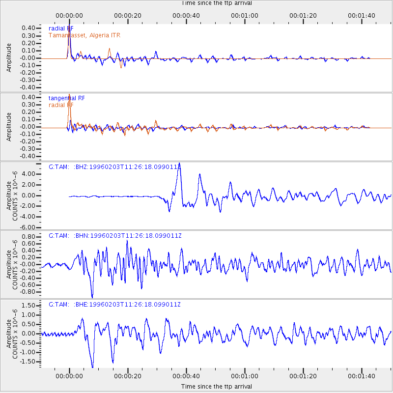
Signal To Noise
| Channel | StoN | STA | LTA |
| G:TAM: :BHN:19960203T11:26:18.099011Z | 2.8148224 | 1.8137739E-7 | 6.4436534E-8 |
| G:TAM: :BHE:19960203T11:26:18.099011Z | 6.668782 | 3.6161435E-7 | 5.4224948E-8 |
| G:TAM: :BHZ:19960203T11:26:18.099011Z | 18.866173 | 1.0753408E-6 | 5.6998356E-8 |
| Arrivals |
| Ps | 4.1 SECOND |
| PpPs | 17 SECOND |
| PsPs/PpSs | 21 SECOND |


