You are here: Home > Network List > TA - USArray Transportable Network (new EarthScope stations) Stations List
> Station R40A Maddie's Station, St. Elizabeth, MO, USA > Earthquake Result Viewer
R40A Maddie's Station, St. Elizabeth, MO, USA - Earthquake Result Viewer
| Earthquake location: |
Peru-Brazil Border Region |
| Earthquake latitude/longitude: |
-8.4/-74.3 |
| Earthquake time(UTC): |
2012/08/02 (215) 09:38:30 GMT |
| Earthquake Depth: |
145 km |
| Earthquake Magnitude: |
5.9 MB, 6.1 MW, 6.1 MW |
| Earthquake Catalog/Contributor: |
WHDF/NEIC |
|
| Network: |
TA USArray Transportable Network (new EarthScope stations) |
| Station: |
R40A Maddie's Station, St. Elizabeth, MO, USA |
| Lat/Lon: |
38.29 N/92.27 W |
| Elevation: |
213 m |
|
| Distance: |
49.4 deg |
| Az: |
341.314 deg |
| Baz: |
156.245 deg |
| Ray Param: |
0.06822587 |
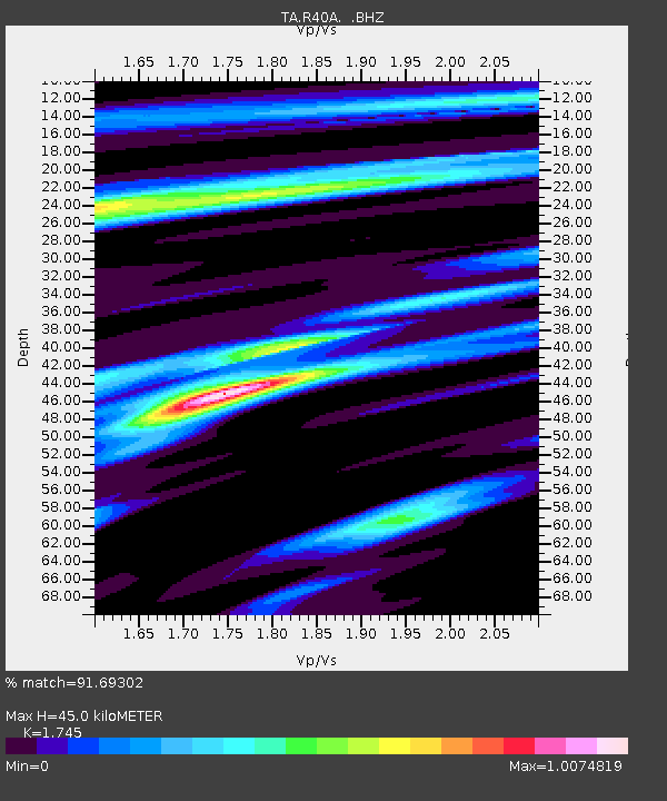
| Estimated Moho Depth: |
45.0 km |
| Estimated Crust Vp/Vs: |
1.75 |
| Assumed Crust Vp: |
6.498 km/s |
| Estimated Crust Vs: |
3.724 km/s |
| Estimated Crust Poisson's Ratio: |
0.26 |
|
| Radial Match: |
91.69302 % |
| Radial Bump: |
349 |
| Transverse Match: |
69.1567 % |
| Transverse Bump: |
400 |
| SOD ConfigId: |
469095 |
| Insert Time: |
2013-02-22 03:19:24.339 +0000 |
| GWidth: |
2.5 |
| Max Bumps: |
400 |
| Tol: |
0.001 |
|

Signal To Noise
| Channel | StoN | STA | LTA |
| TA:R40A: :BHZ:20120802T09:46:35.350Z | 23.302149 | 9.961844E-7 | 4.2750756E-8 |
| TA:R40A: :BHN:20120802T09:46:35.350Z | 8.518614 | 4.2974776E-7 | 5.0448087E-8 |
| TA:R40A: :BHE:20120802T09:46:35.350Z | 5.782775 | 2.4769759E-7 | 4.2833687E-8 |
| Arrivals |
| Ps | 5.5 SECOND |
| PpPs | 18 SECOND |
| PsPs/PpSs | 23 SECOND |


