You are here: Home > Network List > TA - USArray Transportable Network (new EarthScope stations) Stations List
> Station U39A Green Forest, AR, USA > Earthquake Result Viewer
U39A Green Forest, AR, USA - Earthquake Result Viewer
| Earthquake location: |
Peru-Brazil Border Region |
| Earthquake latitude/longitude: |
-8.4/-74.3 |
| Earthquake time(UTC): |
2012/08/02 (215) 09:38:30 GMT |
| Earthquake Depth: |
145 km |
| Earthquake Magnitude: |
5.9 MB, 6.1 MW, 6.1 MW |
| Earthquake Catalog/Contributor: |
WHDF/NEIC |
|
| Network: |
TA USArray Transportable Network (new EarthScope stations) |
| Station: |
U39A Green Forest, AR, USA |
| Lat/Lon: |
36.38 N/93.48 W |
| Elevation: |
433 m |
|
| Distance: |
48.1 deg |
| Az: |
339.082 deg |
| Baz: |
154.041 deg |
| Ray Param: |
0.069069855 |
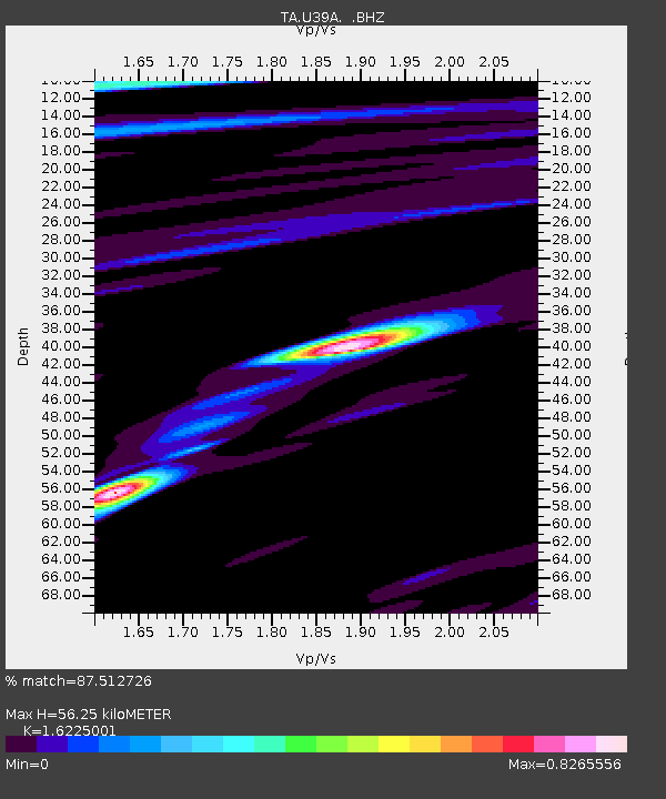
| Estimated Moho Depth: |
56.25 km |
| Estimated Crust Vp/Vs: |
1.62 |
| Assumed Crust Vp: |
6.53 km/s |
| Estimated Crust Vs: |
4.025 km/s |
| Estimated Crust Poisson's Ratio: |
0.19 |
|
| Radial Match: |
87.512726 % |
| Radial Bump: |
400 |
| Transverse Match: |
66.35543 % |
| Transverse Bump: |
400 |
| SOD ConfigId: |
469095 |
| Insert Time: |
2013-02-22 03:20:13.226 +0000 |
| GWidth: |
2.5 |
| Max Bumps: |
400 |
| Tol: |
0.001 |
|
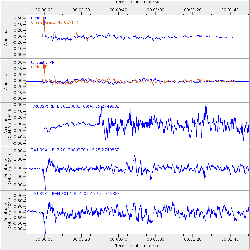
Signal To Noise
| Channel | StoN | STA | LTA |
| TA:U39A: :BHZ:20120802T09:46:25.274988Z | 19.025118 | 9.0818224E-7 | 4.7735956E-8 |
| TA:U39A: :BHN:20120802T09:46:25.274988Z | 7.6975403 | 4.320117E-7 | 5.6123344E-8 |
| TA:U39A: :BHE:20120802T09:46:25.274988Z | 3.5095043 | 2.6249737E-7 | 7.479614E-8 |
| Arrivals |
| Ps | 5.7 SECOND |
| PpPs | 21 SECOND |
| PsPs/PpSs | 27 SECOND |


