You are here: Home > Network List > TA - USArray Transportable Network (new EarthScope stations) Stations List
> Station 240A Hunter Patterson, Mansfield, LA, USA > Earthquake Result Viewer
240A Hunter Patterson, Mansfield, LA, USA - Earthquake Result Viewer
| Earthquake location: |
Peru-Brazil Border Region |
| Earthquake latitude/longitude: |
-8.4/-74.3 |
| Earthquake time(UTC): |
2012/08/02 (215) 09:38:30 GMT |
| Earthquake Depth: |
145 km |
| Earthquake Magnitude: |
5.9 MB, 6.1 MW, 6.1 MW |
| Earthquake Catalog/Contributor: |
WHDF/NEIC |
|
| Network: |
TA USArray Transportable Network (new EarthScope stations) |
| Station: |
240A Hunter Patterson, Mansfield, LA, USA |
| Lat/Lon: |
32.04 N/93.76 W |
| Elevation: |
119 m |
|
| Distance: |
44.3 deg |
| Az: |
336.061 deg |
| Baz: |
151.791 deg |
| Ray Param: |
0.07145956 |
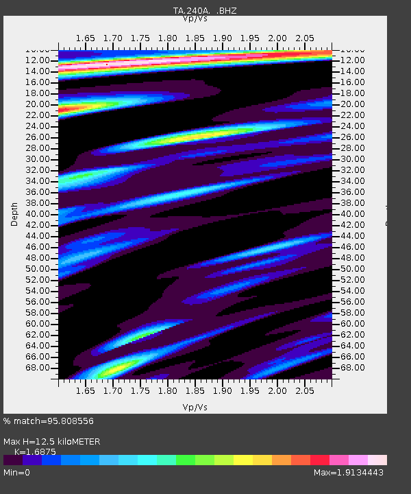
| Estimated Moho Depth: |
12.5 km |
| Estimated Crust Vp/Vs: |
1.69 |
| Assumed Crust Vp: |
6.245 km/s |
| Estimated Crust Vs: |
3.701 km/s |
| Estimated Crust Poisson's Ratio: |
0.23 |
|
| Radial Match: |
95.808556 % |
| Radial Bump: |
349 |
| Transverse Match: |
88.2042 % |
| Transverse Bump: |
400 |
| SOD ConfigId: |
469095 |
| Insert Time: |
2013-02-22 03:20:58.457 +0000 |
| GWidth: |
2.5 |
| Max Bumps: |
400 |
| Tol: |
0.001 |
|

Signal To Noise
| Channel | StoN | STA | LTA |
| TA:240A: :BHZ:20120802T09:45:56.024988Z | 20.370588 | 1.9319855E-6 | 9.484191E-8 |
| TA:240A: :BHN:20120802T09:45:56.024988Z | 6.5938606 | 7.973569E-7 | 1.2092413E-7 |
| TA:240A: :BHE:20120802T09:45:56.024988Z | 3.1515431 | 4.5703086E-7 | 1.4501812E-7 |
| Arrivals |
| Ps | 1.5 SECOND |
| PpPs | 5.0 SECOND |
| PsPs/PpSs | 6.5 SECOND |


