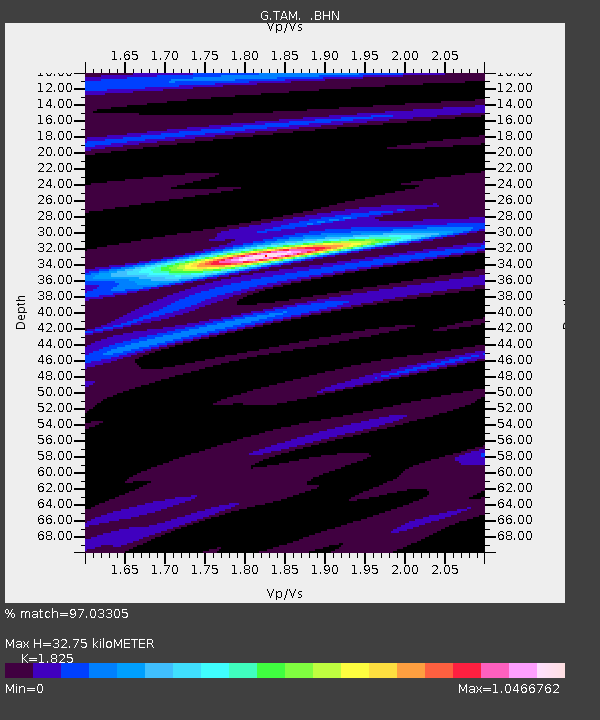
TAM Tamanrasset, Algeria - Earthquake Result Viewer
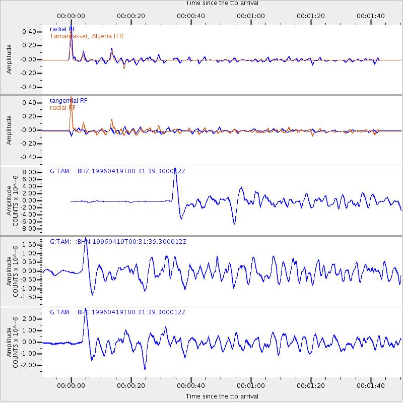
Earthquake location: Near Coast Of Northern Chile
Earthquake latitude/longitude: -23.9/-70.1
Earthquake time(UTC): 1996/04/19 (110) 00:19:31 GMT
Earthquake Depth: 50 km
Earthquake Magnitude: 6.0 MB, 6.1 MS, 6.6 UNKNOWN, 6.5 ME
Earthquake Catalog/Contributor: WHDF/NEIC
Network: G GEOSCOPE
Station: TAM Tamanrasset, Algeria
Lat/Lon: 22.79 N/5.53 E
Elevation: 1377 m
Distance: 86.9 deg
Az: 63.541 deg
Baz: 242.572 deg
Ray Param: 0.043637674
Estimated Moho Depth: 32.75 km
Estimated Crust Vp/Vs: 1.83
Assumed Crust Vp: 6.61 km/s
Estimated Crust Vs: 3.622 km/s
Estimated Crust Poisson's Ratio: 0.29
Radial Match: 97.03305 %
Radial Bump: 302
Transverse Match: 86.44666 %
Transverse Bump: 400
SOD ConfigId: 6273
Insert Time: 2010-02-27 00:29:34.139 +0000
GWidth: 2.5
Max Bumps: 400
Tol: 0.001

Signal To Noise

ChannelStoNSTALTA
G:TAM: :BHN:19960419T00:31:39.300012Z6.767485.5907134E-78.261144E-8
G:TAM: :BHE:19960419T00:31:39.300012Z15.8358018.483233E-75.3569963E-8
G:TAM: :BHZ:19960419T00:31:39.300012Z33.2704052.952521E-68.8743164E-8
Arrivals
Ps4.2 SECOND
PpPs14 SECOND
PsPs/PpSs18 SECOND