You are here: Home > Network List > TA - USArray Transportable Network (new EarthScope stations) Stations List
> Station 348A Jackson, AL, USA > Earthquake Result Viewer
348A Jackson, AL, USA - Earthquake Result Viewer
| Earthquake location: |
Peru-Brazil Border Region |
| Earthquake latitude/longitude: |
-8.4/-74.3 |
| Earthquake time(UTC): |
2012/08/02 (215) 09:38:30 GMT |
| Earthquake Depth: |
145 km |
| Earthquake Magnitude: |
5.9 MB, 6.1 MW, 6.1 MW |
| Earthquake Catalog/Contributor: |
WHDF/NEIC |
|
| Network: |
TA USArray Transportable Network (new EarthScope stations) |
| Station: |
348A Jackson, AL, USA |
| Lat/Lon: |
31.41 N/87.90 W |
| Elevation: |
57 m |
|
| Distance: |
41.7 deg |
| Az: |
342.353 deg |
| Baz: |
159.463 deg |
| Ray Param: |
0.073104426 |
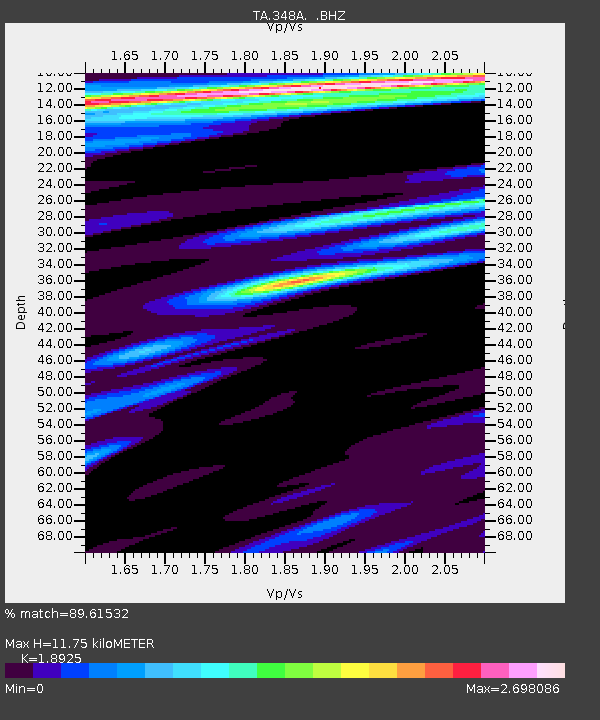
| Estimated Moho Depth: |
11.75 km |
| Estimated Crust Vp/Vs: |
1.89 |
| Assumed Crust Vp: |
6.187 km/s |
| Estimated Crust Vs: |
3.269 km/s |
| Estimated Crust Poisson's Ratio: |
0.31 |
|
| Radial Match: |
89.61532 % |
| Radial Bump: |
400 |
| Transverse Match: |
69.2487 % |
| Transverse Bump: |
400 |
| SOD ConfigId: |
469095 |
| Insert Time: |
2013-02-22 03:24:00.199 +0000 |
| GWidth: |
2.5 |
| Max Bumps: |
400 |
| Tol: |
0.001 |
|
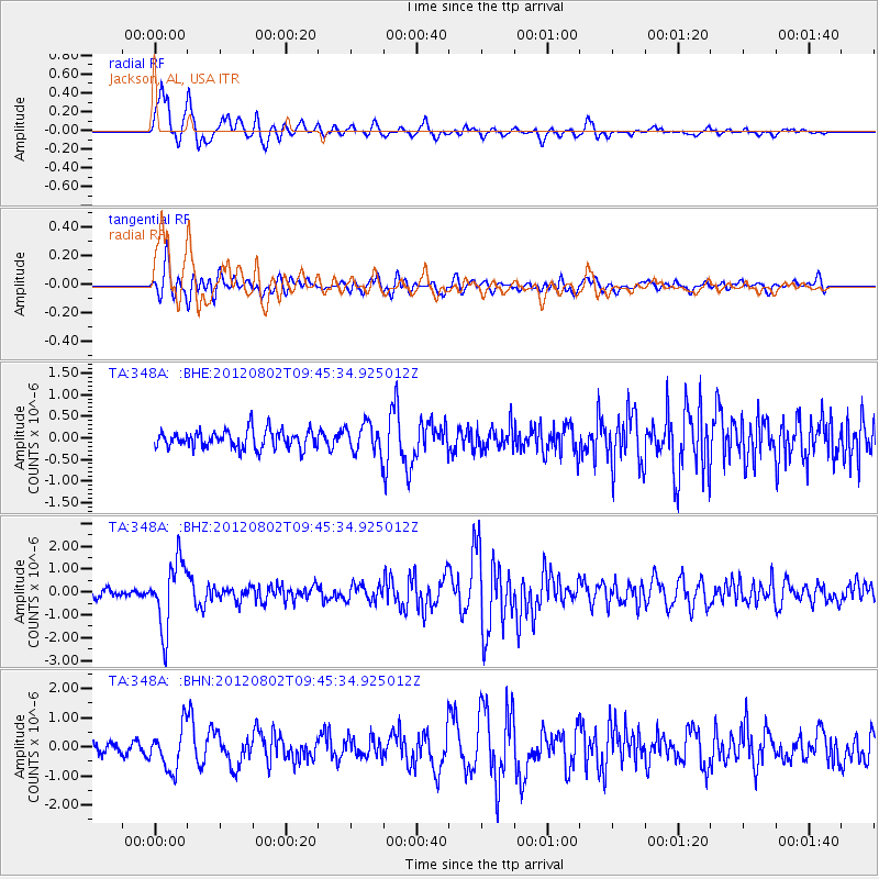
Signal To Noise
| Channel | StoN | STA | LTA |
| TA:348A: :BHZ:20120802T09:45:34.925012Z | 10.449347 | 1.4720995E-6 | 1.4087956E-7 |
| TA:348A: :BHN:20120802T09:45:34.925012Z | 4.803532 | 7.24875E-7 | 1.5090458E-7 |
| TA:348A: :BHE:20120802T09:45:34.925012Z | 1.6265211 | 3.4190964E-7 | 2.1020917E-7 |
| Arrivals |
| Ps | 1.8 SECOND |
| PpPs | 5.2 SECOND |
| PsPs/PpSs | 7.0 SECOND |


