You are here: Home > Network List > TA - USArray Transportable Network (new EarthScope stations) Stations List
> Station Z47A Carrollton, AL, USA > Earthquake Result Viewer
Z47A Carrollton, AL, USA - Earthquake Result Viewer
| Earthquake location: |
Peru-Brazil Border Region |
| Earthquake latitude/longitude: |
-8.4/-74.3 |
| Earthquake time(UTC): |
2012/08/02 (215) 09:38:30 GMT |
| Earthquake Depth: |
145 km |
| Earthquake Magnitude: |
5.9 MB, 6.1 MW, 6.1 MW |
| Earthquake Catalog/Contributor: |
WHDF/NEIC |
|
| Network: |
TA USArray Transportable Network (new EarthScope stations) |
| Station: |
Z47A Carrollton, AL, USA |
| Lat/Lon: |
33.20 N/88.07 W |
| Elevation: |
65 m |
|
| Distance: |
43.4 deg |
| Az: |
343.07 deg |
| Baz: |
159.903 deg |
| Ray Param: |
0.07202573 |
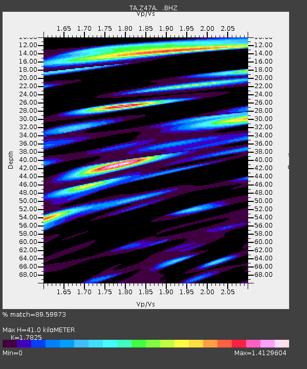
| Estimated Moho Depth: |
41.0 km |
| Estimated Crust Vp/Vs: |
1.78 |
| Assumed Crust Vp: |
6.201 km/s |
| Estimated Crust Vs: |
3.479 km/s |
| Estimated Crust Poisson's Ratio: |
0.27 |
|
| Radial Match: |
89.59973 % |
| Radial Bump: |
400 |
| Transverse Match: |
74.499084 % |
| Transverse Bump: |
400 |
| SOD ConfigId: |
469095 |
| Insert Time: |
2013-02-22 03:25:21.712 +0000 |
| GWidth: |
2.5 |
| Max Bumps: |
400 |
| Tol: |
0.001 |
|
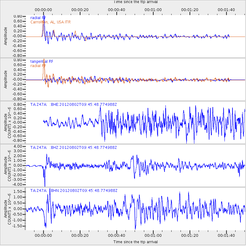
Signal To Noise
| Channel | StoN | STA | LTA |
| TA:Z47A: :BHZ:20120802T09:45:48.774988Z | 15.929555 | 1.3188676E-6 | 8.2793754E-8 |
| TA:Z47A: :BHN:20120802T09:45:48.774988Z | 8.606624 | 8.5290566E-7 | 9.9098756E-8 |
| TA:Z47A: :BHE:20120802T09:45:48.774988Z | 2.938604 | 3.510636E-7 | 1.1946611E-7 |
| Arrivals |
| Ps | 5.5 SECOND |
| PpPs | 17 SECOND |
| PsPs/PpSs | 23 SECOND |


