You are here: Home > Network List > TA - USArray Transportable Network (new EarthScope stations) Stations List
> Station P39B Salisbury, MO, USA > Earthquake Result Viewer
P39B Salisbury, MO, USA - Earthquake Result Viewer
| Earthquake location: |
Peru-Brazil Border Region |
| Earthquake latitude/longitude: |
-8.4/-74.3 |
| Earthquake time(UTC): |
2012/08/02 (215) 09:38:30 GMT |
| Earthquake Depth: |
145 km |
| Earthquake Magnitude: |
5.9 MB, 6.1 MW, 6.1 MW |
| Earthquake Catalog/Contributor: |
WHDF/NEIC |
|
| Network: |
TA USArray Transportable Network (new EarthScope stations) |
| Station: |
P39B Salisbury, MO, USA |
| Lat/Lon: |
39.49 N/92.75 W |
| Elevation: |
226 m |
|
| Distance: |
50.7 deg |
| Az: |
341.492 deg |
| Baz: |
156.055 deg |
| Ray Param: |
0.06742748 |
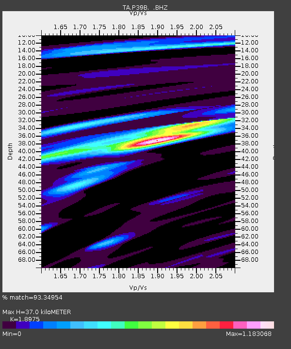
| Estimated Moho Depth: |
37.0 km |
| Estimated Crust Vp/Vs: |
1.90 |
| Assumed Crust Vp: |
6.498 km/s |
| Estimated Crust Vs: |
3.424 km/s |
| Estimated Crust Poisson's Ratio: |
0.31 |
|
| Radial Match: |
93.34954 % |
| Radial Bump: |
400 |
| Transverse Match: |
74.46479 % |
| Transverse Bump: |
400 |
| SOD ConfigId: |
469095 |
| Insert Time: |
2013-02-22 03:25:50.221 +0000 |
| GWidth: |
2.5 |
| Max Bumps: |
400 |
| Tol: |
0.001 |
|

Signal To Noise
| Channel | StoN | STA | LTA |
| TA:P39B: :BHZ:20120802T09:46:44.725Z | 26.152203 | 1.3974434E-6 | 5.3435016E-8 |
| TA:P39B: :BHN:20120802T09:46:44.725Z | 12.181105 | 7.0667846E-7 | 5.801432E-8 |
| TA:P39B: :BHE:20120802T09:46:44.725Z | 5.6629605 | 3.4660815E-7 | 6.120617E-8 |
| Arrivals |
| Ps | 5.4 SECOND |
| PpPs | 16 SECOND |
| PsPs/PpSs | 21 SECOND |


