You are here: Home > Network List > TA - USArray Transportable Network (new EarthScope stations) Stations List
> Station X44A Crenshaw, MS, USA > Earthquake Result Viewer
X44A Crenshaw, MS, USA - Earthquake Result Viewer
| Earthquake location: |
Peru-Brazil Border Region |
| Earthquake latitude/longitude: |
-8.4/-74.3 |
| Earthquake time(UTC): |
2012/08/02 (215) 09:38:30 GMT |
| Earthquake Depth: |
145 km |
| Earthquake Magnitude: |
5.9 MB, 6.1 MW, 6.1 MW |
| Earthquake Catalog/Contributor: |
WHDF/NEIC |
|
| Network: |
TA USArray Transportable Network (new EarthScope stations) |
| Station: |
X44A Crenshaw, MS, USA |
| Lat/Lon: |
34.50 N/90.15 W |
| Elevation: |
109 m |
|
| Distance: |
45.3 deg |
| Az: |
341.439 deg |
| Baz: |
157.584 deg |
| Ray Param: |
0.070868306 |
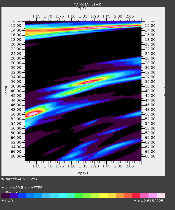
| Estimated Moho Depth: |
49.5 km |
| Estimated Crust Vp/Vs: |
1.63 |
| Assumed Crust Vp: |
6.273 km/s |
| Estimated Crust Vs: |
3.837 km/s |
| Estimated Crust Poisson's Ratio: |
0.20 |
|
| Radial Match: |
86.19254 % |
| Radial Bump: |
377 |
| Transverse Match: |
72.6327 % |
| Transverse Bump: |
395 |
| SOD ConfigId: |
469095 |
| Insert Time: |
2013-02-22 03:26:13.584 +0000 |
| GWidth: |
2.5 |
| Max Bumps: |
400 |
| Tol: |
0.001 |
|
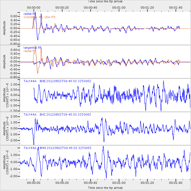
Signal To Noise
| Channel | StoN | STA | LTA |
| TA:X44A: :BHZ:20120802T09:46:03.325006Z | 9.33129 | 1.1001126E-6 | 1.1789501E-7 |
| TA:X44A: :BHN:20120802T09:46:03.325006Z | 4.7822556 | 1.0517552E-6 | 2.1992871E-7 |
| TA:X44A: :BHE:20120802T09:46:03.325006Z | 1.5518488 | 5.3571125E-7 | 3.452084E-7 |
| Arrivals |
| Ps | 5.3 SECOND |
| PpPs | 19 SECOND |
| PsPs/PpSs | 25 SECOND |


