You are here: Home > Network List > TA - USArray Transportable Network (new EarthScope stations) Stations List
> Station X43A Marvell, AR, USA > Earthquake Result Viewer
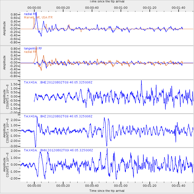
X43A Marvell, AR, USA - Earthquake Result Viewer
*The percent match for this event was below the threshold and hence no stack was calculated.
| Earthquake location: |
Peru-Brazil Border Region |
| Earthquake latitude/longitude: |
-8.4/-74.3 |
| Earthquake time(UTC): |
2012/08/02 (215) 09:38:30 GMT |
| Earthquake Depth: |
145 km |
| Earthquake Magnitude: |
5.9 MB, 6.1 MW, 6.1 MW |
| Earthquake Catalog/Contributor: |
WHDF/NEIC |
|
| Network: |
TA USArray Transportable Network (new EarthScope stations) |
| Station: |
X43A Marvell, AR, USA |
| Lat/Lon: |
34.52 N/90.88 W |
| Elevation: |
53 m |
|
| Distance: |
45.5 deg |
| Az: |
340.663 deg |
| Baz: |
156.625 deg |
| Ray Param: |
$rayparam |
*The percent match for this event was below the threshold and hence was not used in the summary stack. |
|
| Radial Match: |
87.30089 % |
| Radial Bump: |
333 |
| Transverse Match: |
67.02023 % |
| Transverse Bump: |
400 |
| SOD ConfigId: |
469095 |
| Insert Time: |
2013-02-22 03:26:59.146 +0000 |
| GWidth: |
2.5 |
| Max Bumps: |
400 |
| Tol: |
0.001 |
|
Signal To Noise
| Channel | StoN | STA | LTA |
| TA:X43A: :BHZ:20120802T09:46:05.325006Z | 11.659887 | 1.4524135E-6 | 1.2456496E-7 |
| TA:X43A: :BHN:20120802T09:46:05.325006Z | 4.772745 | 1.1021973E-6 | 2.3093571E-7 |
| TA:X43A: :BHE:20120802T09:46:05.325006Z | 1.9604009 | 5.00445E-7 | 2.552769E-7 |
| Arrivals |
| Ps | |
| PpPs | |
| PsPs/PpSs | |


