You are here: Home > Network List > TA - USArray Transportable Network (new EarthScope stations) Stations List
> Station L41A Preston, IA, USA > Earthquake Result Viewer
L41A Preston, IA, USA - Earthquake Result Viewer
| Earthquake location: |
Peru-Brazil Border Region |
| Earthquake latitude/longitude: |
-8.4/-74.3 |
| Earthquake time(UTC): |
2012/08/02 (215) 09:38:30 GMT |
| Earthquake Depth: |
145 km |
| Earthquake Magnitude: |
5.9 MB, 6.1 MW, 6.1 MW |
| Earthquake Catalog/Contributor: |
WHDF/NEIC |
|
| Network: |
TA USArray Transportable Network (new EarthScope stations) |
| Station: |
L41A Preston, IA, USA |
| Lat/Lon: |
42.08 N/90.50 W |
| Elevation: |
238 m |
|
| Distance: |
52.4 deg |
| Az: |
344.765 deg |
| Baz: |
159.561 deg |
| Ray Param: |
0.0662958 |
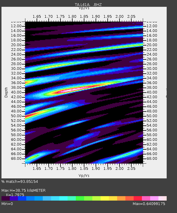
| Estimated Moho Depth: |
38.75 km |
| Estimated Crust Vp/Vs: |
1.80 |
| Assumed Crust Vp: |
6.53 km/s |
| Estimated Crust Vs: |
3.633 km/s |
| Estimated Crust Poisson's Ratio: |
0.28 |
|
| Radial Match: |
93.85154 % |
| Radial Bump: |
400 |
| Transverse Match: |
76.26983 % |
| Transverse Bump: |
400 |
| SOD ConfigId: |
469095 |
| Insert Time: |
2013-02-22 03:27:35.002 +0000 |
| GWidth: |
2.5 |
| Max Bumps: |
400 |
| Tol: |
0.001 |
|

Signal To Noise
| Channel | StoN | STA | LTA |
| TA:L41A: :BHZ:20120802T09:46:57.675012Z | 21.630917 | 1.5847074E-6 | 7.3261226E-8 |
| TA:L41A: :BHN:20120802T09:46:57.675012Z | 10.687183 | 6.781988E-7 | 6.345907E-8 |
| TA:L41A: :BHE:20120802T09:46:57.675012Z | 4.490729 | 2.5733019E-7 | 5.7302543E-8 |
| Arrivals |
| Ps | 5.0 SECOND |
| PpPs | 16 SECOND |
| PsPs/PpSs | 21 SECOND |


