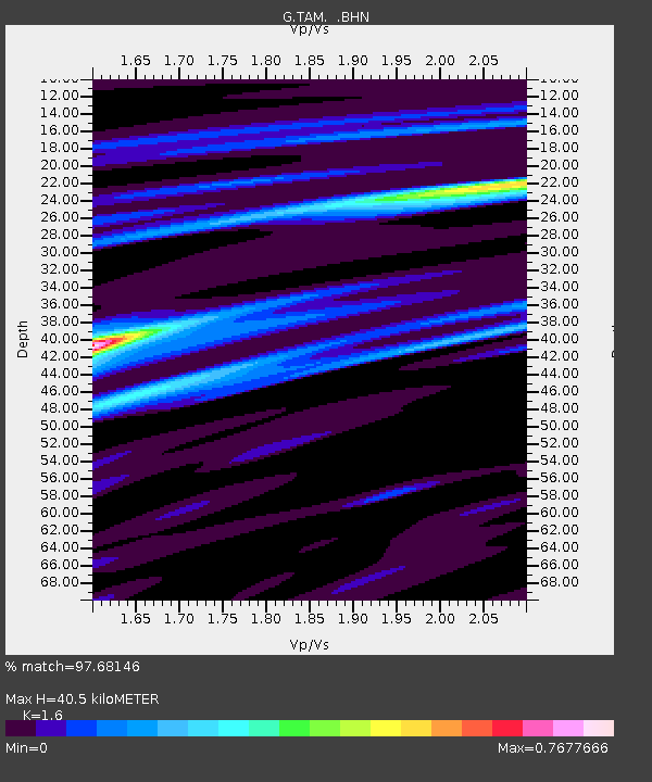
TAM Tamanrasset, Algeria - Earthquake Result Viewer

Earthquake location: Hindu Kush Region, Afghanistan
Earthquake latitude/longitude: 36.4/70.9
Earthquake time(UTC): 1997/05/13 (133) 14:13:45 GMT
Earthquake Depth: 196 km
Earthquake Magnitude: 6.1 MB, 6.5 UNKNOWN, 6.4 MW
Earthquake Catalog/Contributor: WHDF/NEIC
Network: G GEOSCOPE
Station: TAM Tamanrasset, Algeria
Lat/Lon: 22.79 N/5.53 E
Elevation: 1377 m
Distance: 57.5 deg
Az: 275.704 deg
Baz: 60.434 deg
Ray Param: 0.062811255
Estimated Moho Depth: 40.5 km
Estimated Crust Vp/Vs: 1.60
Assumed Crust Vp: 6.61 km/s
Estimated Crust Vs: 4.131 km/s
Estimated Crust Poisson's Ratio: 0.18
Radial Match: 97.68146 %
Radial Bump: 196
Transverse Match: 86.871796 %
Transverse Bump: 400
SOD ConfigId: 6273
Insert Time: 2010-02-27 00:29:50.216 +0000
GWidth: 2.5
Max Bumps: 400
Tol: 0.001

Signal To Noise

ChannelStoNSTALTA
G:TAM: :BHN:19970513T14:22:43.600024Z14.7475548.593819E-75.8272843E-8
G:TAM: :BHE:19970513T14:22:43.600024Z30.4208931.6603503E-65.4579274E-8
G:TAM: :BHZ:19970513T14:22:43.600024Z48.4340323.7716864E-67.787265E-8
Arrivals
Ps3.9 SECOND
PpPs15 SECOND
PsPs/PpSs19 SECOND