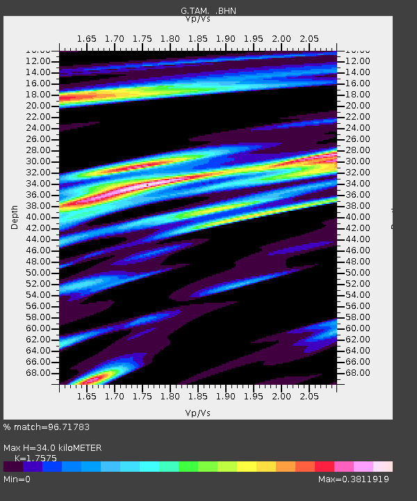
TAM Tamanrasset, Algeria - Earthquake Result Viewer

Earthquake location: South Sandwich Islands Region
Earthquake latitude/longitude: -57.8/-25.5
Earthquake time(UTC): 1997/06/02 (153) 21:24:38 GMT
Earthquake Depth: 33 km
Earthquake Magnitude: 5.9 MB, 5.8 MS, 6.1 UNKNOWN, 6.1 MW
Earthquake Catalog/Contributor: WHDF/NEIC
Network: G GEOSCOPE
Station: TAM Tamanrasset, Algeria
Lat/Lon: 22.79 N/5.53 E
Elevation: 1377 m
Distance: 84.3 deg
Az: 28.525 deg
Baz: 196.096 deg
Ray Param: 0.04551072
Estimated Moho Depth: 34.0 km
Estimated Crust Vp/Vs: 1.76
Assumed Crust Vp: 6.61 km/s
Estimated Crust Vs: 3.761 km/s
Estimated Crust Poisson's Ratio: 0.26
Radial Match: 96.71783 %
Radial Bump: 292
Transverse Match: 88.09268 %
Transverse Bump: 400
SOD ConfigId: 6273
Insert Time: 2010-02-27 00:29:54.181 +0000
GWidth: 2.5
Max Bumps: 400
Tol: 0.001

Signal To Noise

ChannelStoNSTALTA
G:TAM: :BHN:19970602T21:36:35.949011Z14.8363354.928379E-73.3218303E-8
G:TAM: :BHE:19970602T21:36:35.949011Z2.75291941.4824667E-75.3850712E-8
G:TAM: :BHZ:19970602T21:36:35.949011Z19.2385731.3507399E-67.020998E-8
Arrivals
Ps4.0 SECOND
PpPs14 SECOND
PsPs/PpSs18 SECOND