You are here: Home > Network List > TA - USArray Transportable Network (new EarthScope stations) Stations List
> Station H40A Chili, WI, USA > Earthquake Result Viewer
H40A Chili, WI, USA - Earthquake Result Viewer
| Earthquake location: |
Peru-Brazil Border Region |
| Earthquake latitude/longitude: |
-8.4/-74.3 |
| Earthquake time(UTC): |
2012/08/02 (215) 09:38:30 GMT |
| Earthquake Depth: |
145 km |
| Earthquake Magnitude: |
5.9 MB, 6.1 MW, 6.1 MW |
| Earthquake Catalog/Contributor: |
WHDF/NEIC |
|
| Network: |
TA USArray Transportable Network (new EarthScope stations) |
| Station: |
H40A Chili, WI, USA |
| Lat/Lon: |
44.62 N/90.39 W |
| Elevation: |
372 m |
|
| Distance: |
54.8 deg |
| Az: |
345.941 deg |
| Baz: |
160.333 deg |
| Ray Param: |
0.06476121 |
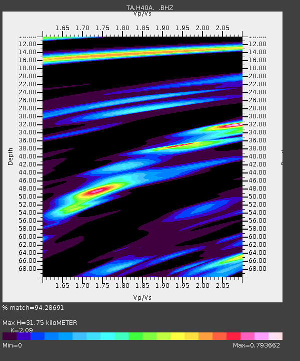
| Estimated Moho Depth: |
31.75 km |
| Estimated Crust Vp/Vs: |
2.09 |
| Assumed Crust Vp: |
6.571 km/s |
| Estimated Crust Vs: |
3.144 km/s |
| Estimated Crust Poisson's Ratio: |
0.35 |
|
| Radial Match: |
94.28691 % |
| Radial Bump: |
313 |
| Transverse Match: |
83.375374 % |
| Transverse Bump: |
400 |
| SOD ConfigId: |
469095 |
| Insert Time: |
2013-02-22 03:30:34.454 +0000 |
| GWidth: |
2.5 |
| Max Bumps: |
400 |
| Tol: |
0.001 |
|
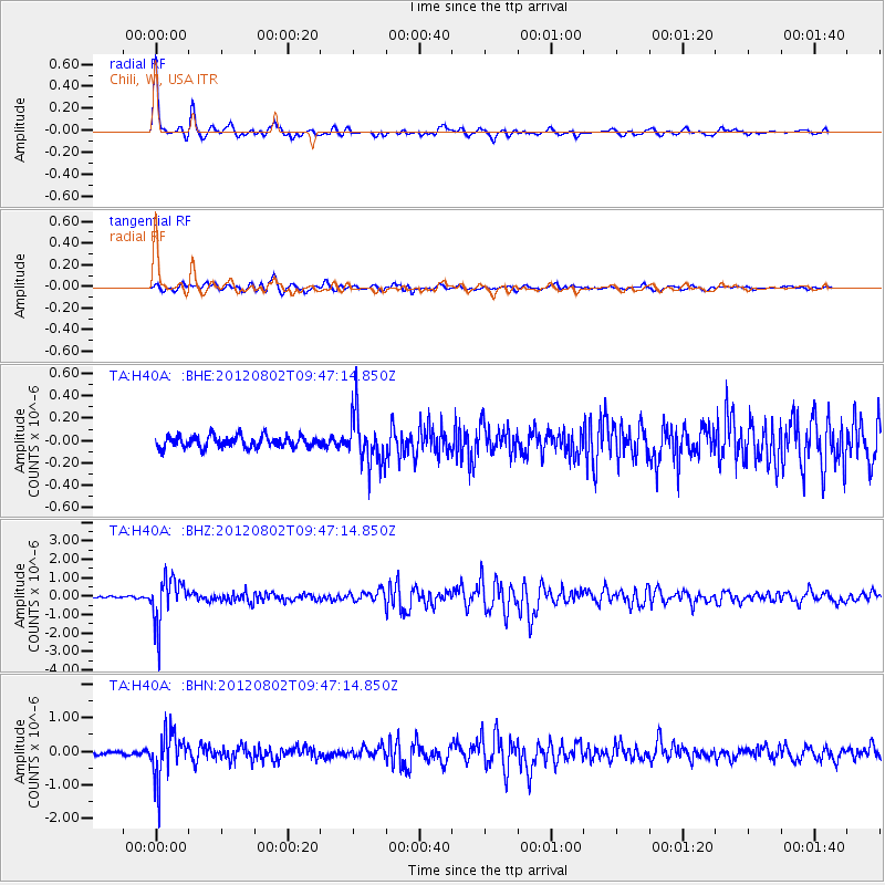
Signal To Noise
| Channel | StoN | STA | LTA |
| TA:H40A: :BHZ:20120802T09:47:14.850Z | 18.873291 | 1.2401563E-6 | 6.570959E-8 |
| TA:H40A: :BHN:20120802T09:47:14.850Z | 14.13439 | 7.0465745E-7 | 4.9854112E-8 |
| TA:H40A: :BHE:20120802T09:47:14.850Z | 4.4522657 | 2.2392989E-7 | 5.0295714E-8 |
| Arrivals |
| Ps | 5.5 SECOND |
| PpPs | 14 SECOND |
| PsPs/PpSs | 20 SECOND |


