You are here: Home > Network List > G - GEOSCOPE Stations List
> Station TAM Tamanrasset, Algeria > Earthquake Result Viewer
TAM Tamanrasset, Algeria - Earthquake Result Viewer
| Earthquake location: |
Colombia |
| Earthquake latitude/longitude: |
3.8/-75.7 |
| Earthquake time(UTC): |
1997/09/02 (245) 12:13:22 GMT |
| Earthquake Depth: |
199 km |
| Earthquake Magnitude: |
6.5 MB, 6.8 UNKNOWN, 6.4 ME |
| Earthquake Catalog/Contributor: |
WHDF/NEIC |
|
| Network: |
G GEOSCOPE |
| Station: |
TAM Tamanrasset, Algeria |
| Lat/Lon: |
22.79 N/5.53 E |
| Elevation: |
1377 m |
|
| Distance: |
80.5 deg |
| Az: |
67.654 deg |
| Baz: |
270.189 deg |
| Ray Param: |
0.047755443 |
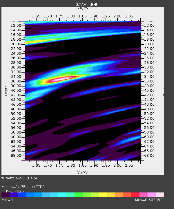
| Estimated Moho Depth: |
34.75 km |
| Estimated Crust Vp/Vs: |
1.76 |
| Assumed Crust Vp: |
6.61 km/s |
| Estimated Crust Vs: |
3.75 km/s |
| Estimated Crust Poisson's Ratio: |
0.26 |
|
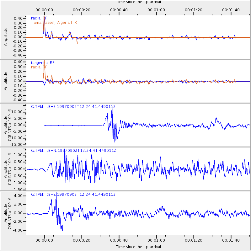
| Radial Match: |
96.26424 % |
| Radial Bump: |
400 |
| Transverse Match: |
80.37401 % |
| Transverse Bump: |
400 |
| SOD ConfigId: |
6273 |
| Insert Time: |
2010-02-27 00:30:03.475 +0000 |
| GWidth: |
2.5 |
| Max Bumps: |
400 |
| Tol: |
0.001 |
|
Signal To Noise
| Channel | StoN | STA | LTA |
| G:TAM: :BHN:19970902T12:24:41.449011Z | 3.8106108 | 2.3471306E-7 | 6.1594605E-8 |
| G:TAM: :BHE:19970902T12:24:41.449011Z | 20.089375 | 1.16417E-6 | 5.794954E-8 |
| G:TAM: :BHZ:19970902T12:24:41.449011Z | 39.9826 | 3.52469E-6 | 8.8155595E-8 |
| Arrivals |
| Ps | 4.1 SECOND |
| PpPs | 14 SECOND |
| PsPs/PpSs | 18 SECOND |


