You are here: Home > Network List > TA - USArray Transportable Network (new EarthScope stations) Stations List
> Station L43A Garden Prairie, IL, USA > Earthquake Result Viewer
L43A Garden Prairie, IL, USA - Earthquake Result Viewer
| Earthquake location: |
Peru-Brazil Border Region |
| Earthquake latitude/longitude: |
-8.4/-74.3 |
| Earthquake time(UTC): |
2012/08/02 (215) 09:38:30 GMT |
| Earthquake Depth: |
145 km |
| Earthquake Magnitude: |
5.9 MB, 6.1 MW, 6.1 MW |
| Earthquake Catalog/Contributor: |
WHDF/NEIC |
|
| Network: |
TA USArray Transportable Network (new EarthScope stations) |
| Station: |
L43A Garden Prairie, IL, USA |
| Lat/Lon: |
42.18 N/88.74 W |
| Elevation: |
266 m |
|
| Distance: |
52.1 deg |
| Az: |
346.369 deg |
| Baz: |
161.717 deg |
| Ray Param: |
0.0665154 |
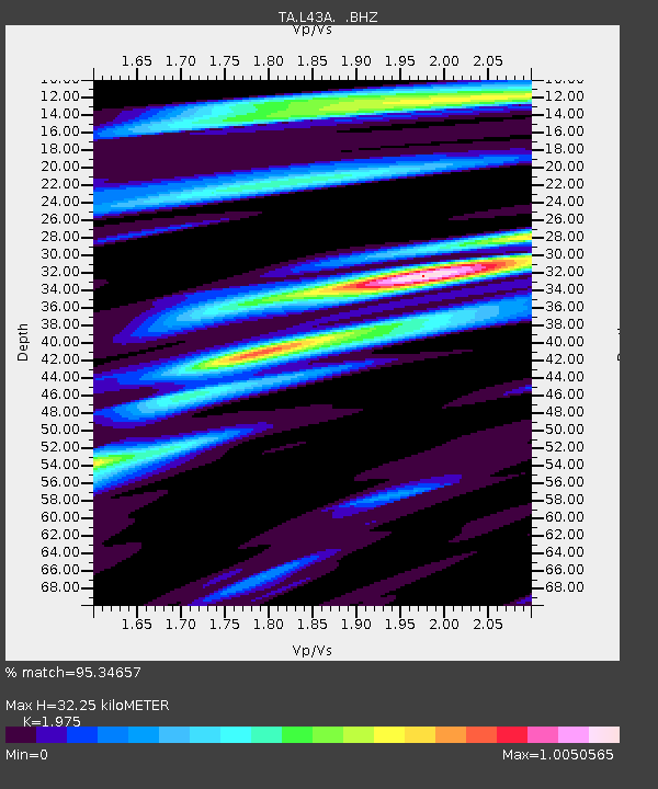
| Estimated Moho Depth: |
32.25 km |
| Estimated Crust Vp/Vs: |
1.98 |
| Assumed Crust Vp: |
6.571 km/s |
| Estimated Crust Vs: |
3.327 km/s |
| Estimated Crust Poisson's Ratio: |
0.33 |
|
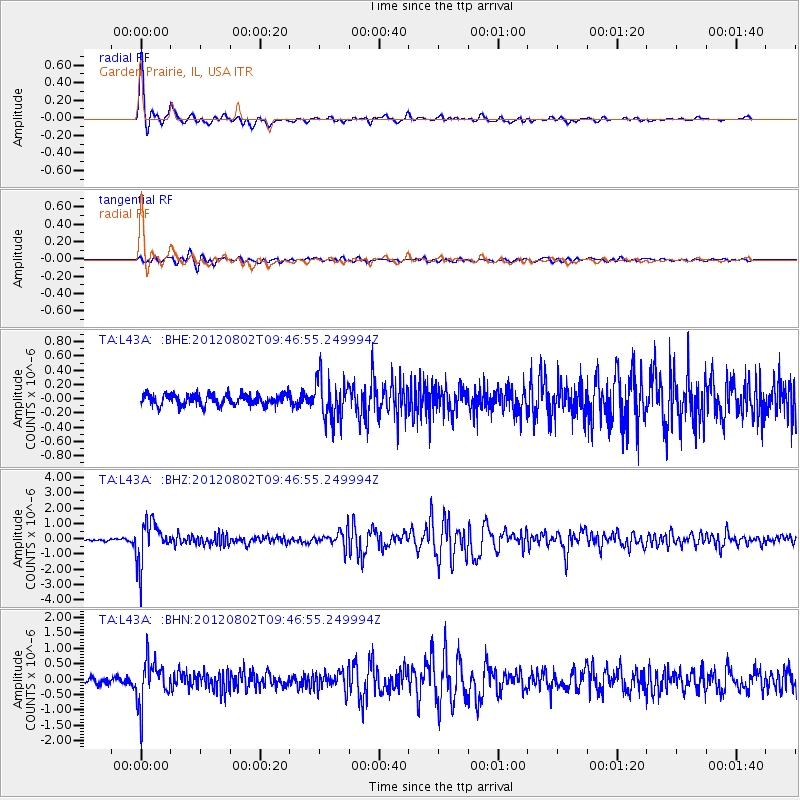
| Radial Match: |
95.34657 % |
| Radial Bump: |
332 |
| Transverse Match: |
78.037605 % |
| Transverse Bump: |
400 |
| SOD ConfigId: |
469095 |
| Insert Time: |
2013-02-22 03:33:18.163 +0000 |
| GWidth: |
2.5 |
| Max Bumps: |
400 |
| Tol: |
0.001 |
|
Signal To Noise
| Channel | StoN | STA | LTA |
| TA:L43A: :BHZ:20120802T09:46:55.249994Z | 17.553244 | 1.3628023E-6 | 7.7638205E-8 |
| TA:L43A: :BHN:20120802T09:46:55.249994Z | 8.679956 | 7.2825645E-7 | 8.390093E-8 |
| TA:L43A: :BHE:20120802T09:46:55.249994Z | 3.727517 | 2.8596853E-7 | 7.671824E-8 |
| Arrivals |
| Ps | 5.0 SECOND |
| PpPs | 14 SECOND |
| PsPs/PpSs | 19 SECOND |


