You are here: Home > Network List > TA - USArray Transportable Network (new EarthScope stations) Stations List
> Station E44A Grand Marais Airport, Grand Marais, MI, USA > Earthquake Result Viewer
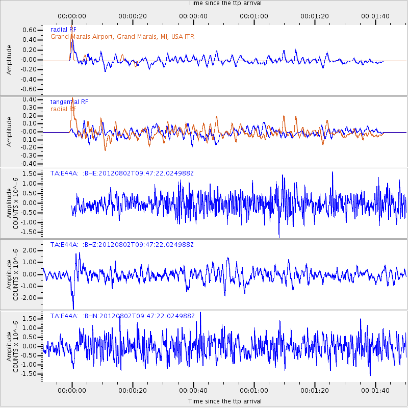
E44A Grand Marais Airport, Grand Marais, MI, USA - Earthquake Result Viewer
*The percent match for this event was below the threshold and hence no stack was calculated.
| Earthquake location: |
Peru-Brazil Border Region |
| Earthquake latitude/longitude: |
-8.4/-74.3 |
| Earthquake time(UTC): |
2012/08/02 (215) 09:38:30 GMT |
| Earthquake Depth: |
145 km |
| Earthquake Magnitude: |
5.9 MB, 6.1 MW, 6.1 MW |
| Earthquake Catalog/Contributor: |
WHDF/NEIC |
|
| Network: |
TA USArray Transportable Network (new EarthScope stations) |
| Station: |
E44A Grand Marais Airport, Grand Marais, MI, USA |
| Lat/Lon: |
46.62 N/85.92 W |
| Elevation: |
282 m |
|
| Distance: |
55.8 deg |
| Az: |
350.298 deg |
| Baz: |
166.001 deg |
| Ray Param: |
$rayparam |
*The percent match for this event was below the threshold and hence was not used in the summary stack. |
|
| Radial Match: |
68.087456 % |
| Radial Bump: |
400 |
| Transverse Match: |
57.422733 % |
| Transverse Bump: |
400 |
| SOD ConfigId: |
469095 |
| Insert Time: |
2013-02-22 03:33:30.227 +0000 |
| GWidth: |
2.5 |
| Max Bumps: |
400 |
| Tol: |
0.001 |
|
Signal To Noise
| Channel | StoN | STA | LTA |
| TA:E44A: :BHZ:20120802T09:47:22.024988Z | 3.8567724 | 1.0620512E-6 | 2.7537305E-7 |
| TA:E44A: :BHN:20120802T09:47:22.024988Z | 1.5710486 | 5.2434007E-7 | 3.3375161E-7 |
| TA:E44A: :BHE:20120802T09:47:22.024988Z | 1.3285512 | 3.8140016E-7 | 2.8707976E-7 |
| Arrivals |
| Ps | |
| PpPs | |
| PsPs/PpSs | |


