You are here: Home > Network List > G - GEOSCOPE Stations List
> Station TAM Tamanrasset, Algeria > Earthquake Result Viewer
TAM Tamanrasset, Algeria - Earthquake Result Viewer

| Earthquake location: |
Northern Peru |
| Earthquake latitude/longitude: |
-4.4/-76.7 |
| Earthquake time(UTC): |
1997/10/28 (301) 06:15:17 GMT |
| Earthquake Depth: |
112 km |
| Earthquake Magnitude: |
6.6 MB, 6.3 MS, 7.2 UNKNOWN, 6.6 ME |
| Earthquake Catalog/Contributor: |
WHDF/NEIC |
|
| Network: |
G GEOSCOPE |
| Station: |
TAM Tamanrasset, Algeria |
| Lat/Lon: |
22.79 N/5.53 E |
| Elevation: |
1377 m |
|
| Distance: |
84.5 deg |
| Az: |
66.713 deg |
| Baz: |
262.967 deg |
| Ray Param: |
0.045182332 |
| Estimated Moho Depth: |
34.5 km |
| Estimated Crust Vp/Vs: |
1.73 |
| Assumed Crust Vp: |
6.61 km/s |
| Estimated Crust Vs: |
3.832 km/s |
| Estimated Crust Poisson's Ratio: |
0.25 |
|
| Radial Match: |
98.224266 % |
| Radial Bump: |
266 |
| Transverse Match: |
93.040215 % |
| Transverse Bump: |
400 |
| SOD ConfigId: |
6273 |
| Insert Time: |
2010-02-27 00:30:07.092 +0000 |
| GWidth: |
2.5 |
| Max Bumps: |
400 |
| Tol: |
0.001 |
|
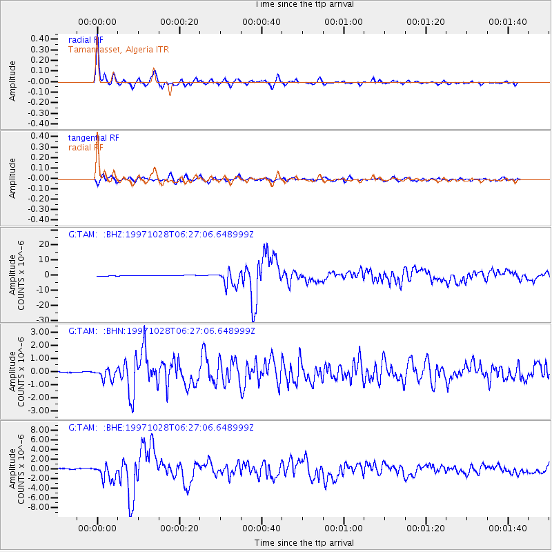
Signal To Noise
| Channel | StoN | STA | LTA |
| G:TAM: :BHN:19971028T06:27:06.648999Z | 7.6121564 | 4.285002E-7 | 5.6291565E-8 |
| G:TAM: :BHE:19971028T06:27:06.648999Z | 18.23166 | 1.717614E-6 | 9.4210506E-8 |
| G:TAM: :BHZ:19971028T06:27:06.648999Z | 28.768564 | 5.474496E-6 | 1.9029437E-7 |
| Arrivals |
| Ps | 3.9 SECOND |
| PpPs | 14 SECOND |
| PsPs/PpSs | 18 SECOND |


